You are here: Home > Network List > TA - USArray Transportable Network (new EarthScope stations) Stations List
> Station V59A Middlesex, NC, USA > Earthquake Result Viewer
V59A Middlesex, NC, USA - Earthquake Result Viewer

| Earthquake location: |
Sea Of Okhotsk |
| Earthquake latitude/longitude: |
54.9/153.2 |
| Earthquake time(UTC): |
2013/05/24 (144) 05:44:48 GMT |
| Earthquake Depth: |
598 km |
| Earthquake Magnitude: |
8.4 MW, 7.5 MB, 8.3 MW |
| Earthquake Catalog/Contributor: |
NEIC PDE/NEIC PDE-W |
|
| Network: |
TA USArray Transportable Network (new EarthScope stations) |
| Station: |
V59A Middlesex, NC, USA |
| Lat/Lon: |
35.76 N/78.24 W |
| Elevation: |
58 m |
|
| Distance: |
79.5 deg |
| Az: |
40.313 deg |
| Baz: |
332.641 deg |
| Ray Param: |
0.047057107 |
| Estimated Moho Depth: |
35.5 km |
| Estimated Crust Vp/Vs: |
1.79 |
| Assumed Crust Vp: |
6.565 km/s |
| Estimated Crust Vs: |
3.662 km/s |
| Estimated Crust Poisson's Ratio: |
0.27 |
|
| Radial Match: |
98.97502 % |
| Radial Bump: |
316 |
| Transverse Match: |
96.85892 % |
| Transverse Bump: |
400 |
| SOD ConfigId: |
512894 |
| Insert Time: |
2013-09-14 17:51:32.171 +0000 |
| GWidth: |
2.5 |
| Max Bumps: |
400 |
| Tol: |
0.001 |
|
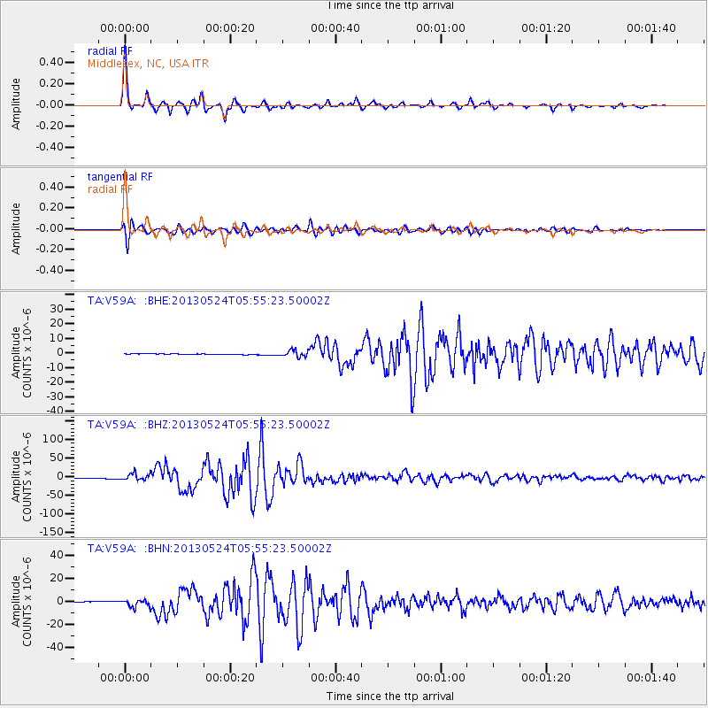
Signal To Noise
| Channel | StoN | STA | LTA |
| TA:V59A: :BHZ:20130524T05:55:23.50002Z | 12.610663 | 9.085357E-6 | 7.204504E-7 |
| TA:V59A: :BHN:20130524T05:55:23.50002Z | 11.193253 | 3.060971E-6 | 2.7346573E-7 |
| TA:V59A: :BHE:20130524T05:55:23.50002Z | 9.52522 | 2.2337786E-6 | 2.3451202E-7 |
| Arrivals |
| Ps | 4.4 SECOND |
| PpPs | 15 SECOND |
| PsPs/PpSs | 19 SECOND |


