You are here: Home > Network List > TA - USArray Transportable Network (new EarthScope stations) Stations List
> Station W47A Westpoint, TN, USA > Earthquake Result Viewer
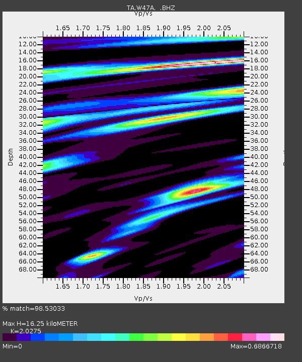
W47A Westpoint, TN, USA - Earthquake Result Viewer
| Earthquake location: |
Sea Of Okhotsk |
| Earthquake latitude/longitude: |
54.9/153.2 |
| Earthquake time(UTC): |
2013/05/24 (144) 05:44:48 GMT |
| Earthquake Depth: |
598 km |
| Earthquake Magnitude: |
8.4 MW, 7.5 MB, 8.3 MW |
| Earthquake Catalog/Contributor: |
NEIC PDE/NEIC PDE-W |
|
| Network: |
TA USArray Transportable Network (new EarthScope stations) |
| Station: |
W47A Westpoint, TN, USA |
| Lat/Lon: |
35.25 N/87.59 W |
| Elevation: |
293 m |
|
| Distance: |
76.2 deg |
| Az: |
47.373 deg |
| Baz: |
328.712 deg |
| Ray Param: |
0.049223 |
| Estimated Moho Depth: |
16.25 km |
| Estimated Crust Vp/Vs: |
2.03 |
| Assumed Crust Vp: |
6.476 km/s |
| Estimated Crust Vs: |
3.194 km/s |
| Estimated Crust Poisson's Ratio: |
0.34 |
|
| Radial Match: |
98.53033 % |
| Radial Bump: |
400 |
| Transverse Match: |
93.21777 % |
| Transverse Bump: |
400 |
| SOD ConfigId: |
512894 |
| Insert Time: |
2013-09-14 17:51:52.108 +0000 |
| GWidth: |
2.5 |
| Max Bumps: |
400 |
| Tol: |
0.001 |
|

Signal To Noise
| Channel | StoN | STA | LTA |
| TA:W47A: :BHZ:20130524T05:55:05.899983Z | 13.039391 | 1.5855645E-5 | 1.2159805E-6 |
| TA:W47A: :BHN:20130524T05:55:05.899983Z | 12.946525 | 6.449901E-6 | 4.981955E-7 |
| TA:W47A: :BHE:20130524T05:55:05.899983Z | 13.162869 | 4.4861977E-6 | 3.4082217E-7 |
| Arrivals |
| Ps | 2.6 SECOND |
| PpPs | 7.4 SECOND |
| PsPs/PpSs | 10 SECOND |


