You are here: Home > Network List > YB13 - Continental Dynamics/Cent. Anatolian Tectonics:Surface to Mantle Dynamics During Stations List
> Station AT20 Kirkpinar,Kersehir,Turkey > Earthquake Result Viewer
AT20 Kirkpinar,Kersehir,Turkey - Earthquake Result Viewer
| Earthquake location: |
Hokkaido, Japan Region |
| Earthquake latitude/longitude: |
41.1/142.2 |
| Earthquake time(UTC): |
2014/08/10 (222) 03:43:16 GMT |
| Earthquake Depth: |
38 km |
| Earthquake Magnitude: |
6.0 MB |
| Earthquake Catalog/Contributor: |
NEIC PDE/NEIC COMCAT |
|
| Network: |
YB Continental Dynamics/Cent. Anatolian Tectonics:Surface to Mantle Dynamics During |
| Station: |
AT20 Kirkpinar,Kersehir,Turkey |
| Lat/Lon: |
39.36 N/34.16 E |
| Elevation: |
1235 m |
|
| Distance: |
76.5 deg |
| Az: |
310.705 deg |
| Baz: |
47.61 deg |
| Ray Param: |
0.05087552 |
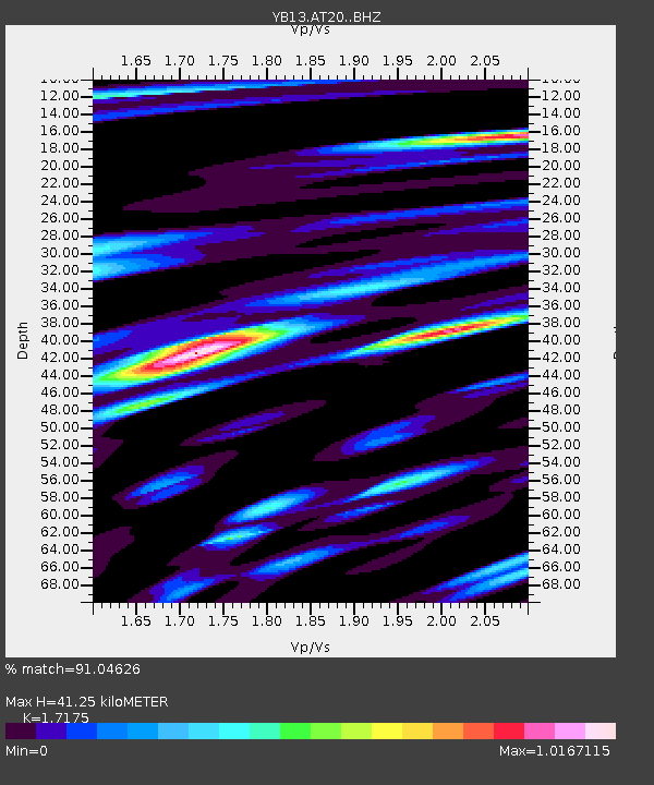
| Estimated Moho Depth: |
41.25 km |
| Estimated Crust Vp/Vs: |
1.72 |
| Assumed Crust Vp: |
6.35 km/s |
| Estimated Crust Vs: |
3.697 km/s |
| Estimated Crust Poisson's Ratio: |
0.24 |
|
| Radial Match: |
91.04626 % |
| Radial Bump: |
400 |
| Transverse Match: |
92.28383 % |
| Transverse Bump: |
400 |
| SOD ConfigId: |
3390531 |
| Insert Time: |
2019-04-13 06:51:09.956 +0000 |
| GWidth: |
2.5 |
| Max Bumps: |
400 |
| Tol: |
0.001 |
|

Signal To Noise
| Channel | StoN | STA | LTA |
| YB:AT20: :BHZ:20140810T03:54:32.339983Z | 42.33814 | 2.728875E-6 | 6.445429E-8 |
| YB:AT20: :BHN:20140810T03:54:32.339983Z | 10.82672 | 7.69043E-7 | 7.103195E-8 |
| YB:AT20: :BHE:20140810T03:54:32.339983Z | 11.903907 | 9.325449E-7 | 7.83394E-8 |
| Arrivals |
| Ps | 4.8 SECOND |
| PpPs | 17 SECOND |
| PsPs/PpSs | 22 SECOND |


