You are here: Home > Network List > TA - USArray Transportable Network (new EarthScope stations) Stations List
> Station WHTX Lake Whitney, Meridian, TX, USA > Earthquake Result Viewer
WHTX Lake Whitney, Meridian, TX, USA - Earthquake Result Viewer
| Earthquake location: |
Sea Of Okhotsk |
| Earthquake latitude/longitude: |
54.9/153.2 |
| Earthquake time(UTC): |
2013/05/24 (144) 05:44:48 GMT |
| Earthquake Depth: |
598 km |
| Earthquake Magnitude: |
8.4 MW, 7.5 MB, 8.3 MW |
| Earthquake Catalog/Contributor: |
NEIC PDE/NEIC PDE-W |
|
| Network: |
TA USArray Transportable Network (new EarthScope stations) |
| Station: |
WHTX Lake Whitney, Meridian, TX, USA |
| Lat/Lon: |
31.99 N/97.46 W |
| Elevation: |
190 m |
|
| Distance: |
74.5 deg |
| Az: |
56.334 deg |
| Baz: |
325.539 deg |
| Ray Param: |
0.050352678 |
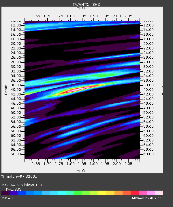
| Estimated Moho Depth: |
39.5 km |
| Estimated Crust Vp/Vs: |
1.84 |
| Assumed Crust Vp: |
6.347 km/s |
| Estimated Crust Vs: |
3.459 km/s |
| Estimated Crust Poisson's Ratio: |
0.29 |
|
| Radial Match: |
97.32661 % |
| Radial Bump: |
400 |
| Transverse Match: |
95.32087 % |
| Transverse Bump: |
400 |
| SOD ConfigId: |
512894 |
| Insert Time: |
2013-09-14 17:52:28.278 +0000 |
| GWidth: |
2.5 |
| Max Bumps: |
400 |
| Tol: |
0.001 |
|

Signal To Noise
| Channel | StoN | STA | LTA |
| TA:WHTX: :BHZ:20130524T05:54:56.248982Z | 14.097855 | 2.4148352E-5 | 1.7129097E-6 |
| TA:WHTX: :BHN:20130524T05:54:56.248982Z | 11.236468 | 7.5003336E-6 | 6.674992E-7 |
| TA:WHTX: :BHE:20130524T05:54:56.248982Z | 8.044267 | 3.6020572E-6 | 4.4777943E-7 |
| Arrivals |
| Ps | 5.3 SECOND |
| PpPs | 17 SECOND |
| PsPs/PpSs | 22 SECOND |


