You are here: Home > Network List > YB13 - Continental Dynamics/Cent. Anatolian Tectonics:Surface to Mantle Dynamics During Stations List
> Station AT28 Suleymanobasi,Gaziantep,Turkey > Earthquake Result Viewer
AT28 Suleymanobasi,Gaziantep,Turkey - Earthquake Result Viewer
| Earthquake location: |
Hokkaido, Japan Region |
| Earthquake latitude/longitude: |
41.1/142.2 |
| Earthquake time(UTC): |
2014/08/10 (222) 03:43:16 GMT |
| Earthquake Depth: |
38 km |
| Earthquake Magnitude: |
6.0 MB |
| Earthquake Catalog/Contributor: |
NEIC PDE/NEIC COMCAT |
|
| Network: |
YB Continental Dynamics/Cent. Anatolian Tectonics:Surface to Mantle Dynamics During |
| Station: |
AT28 Suleymanobasi,Gaziantep,Turkey |
| Lat/Lon: |
37.25 N/37.55 E |
| Elevation: |
839 m |
|
| Distance: |
75.9 deg |
| Az: |
307.256 deg |
| Baz: |
48.885 deg |
| Ray Param: |
0.051270857 |
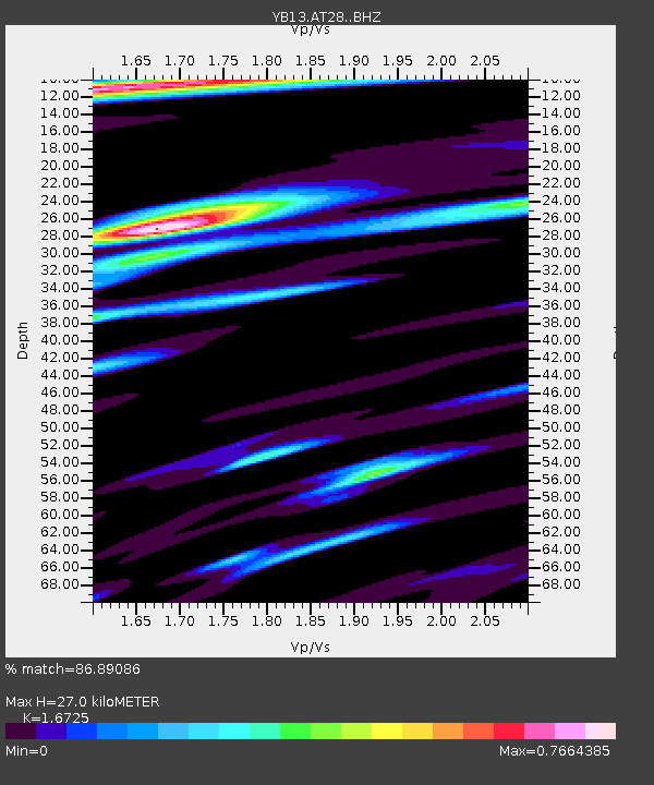
| Estimated Moho Depth: |
27.0 km |
| Estimated Crust Vp/Vs: |
1.67 |
| Assumed Crust Vp: |
6.247 km/s |
| Estimated Crust Vs: |
3.735 km/s |
| Estimated Crust Poisson's Ratio: |
0.22 |
|
| Radial Match: |
86.89086 % |
| Radial Bump: |
400 |
| Transverse Match: |
80.74895 % |
| Transverse Bump: |
400 |
| SOD ConfigId: |
3390531 |
| Insert Time: |
2019-04-13 06:51:14.590 +0000 |
| GWidth: |
2.5 |
| Max Bumps: |
400 |
| Tol: |
0.001 |
|

Signal To Noise
| Channel | StoN | STA | LTA |
| YB:AT28: :BHZ:20140810T03:54:29.019976Z | 40.663647 | 2.8797297E-6 | 7.081828E-8 |
| YB:AT28: :BHN:20140810T03:54:29.019976Z | 8.360167 | 5.2563354E-7 | 6.2873575E-8 |
| YB:AT28: :BHE:20140810T03:54:29.019976Z | 5.659262 | 5.3331627E-7 | 9.423778E-8 |
| Arrivals |
| Ps | 3.0 SECOND |
| PpPs | 11 SECOND |
| PsPs/PpSs | 14 SECOND |


