You are here: Home > Network List > TA - USArray Transportable Network (new EarthScope stations) Stations List
> Station X52A Dahlonega, GA, USA > Earthquake Result Viewer
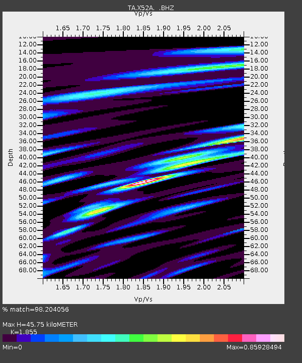
X52A Dahlonega, GA, USA - Earthquake Result Viewer
| Earthquake location: |
Sea Of Okhotsk |
| Earthquake latitude/longitude: |
54.9/153.2 |
| Earthquake time(UTC): |
2013/05/24 (144) 05:44:48 GMT |
| Earthquake Depth: |
598 km |
| Earthquake Magnitude: |
8.4 MW, 7.5 MB, 8.3 MW |
| Earthquake Catalog/Contributor: |
NEIC PDE/NEIC PDE-W |
|
| Network: |
TA USArray Transportable Network (new EarthScope stations) |
| Station: |
X52A Dahlonega, GA, USA |
| Lat/Lon: |
34.60 N/83.89 W |
| Elevation: |
481 m |
|
| Distance: |
78.3 deg |
| Az: |
45.023 deg |
| Baz: |
330.303 deg |
| Ray Param: |
0.047855522 |
| Estimated Moho Depth: |
45.75 km |
| Estimated Crust Vp/Vs: |
1.86 |
| Assumed Crust Vp: |
6.35 km/s |
| Estimated Crust Vs: |
3.423 km/s |
| Estimated Crust Poisson's Ratio: |
0.30 |
|
| Radial Match: |
98.204056 % |
| Radial Bump: |
400 |
| Transverse Match: |
93.69737 % |
| Transverse Bump: |
400 |
| SOD ConfigId: |
512894 |
| Insert Time: |
2013-09-14 17:52:52.551 +0000 |
| GWidth: |
2.5 |
| Max Bumps: |
400 |
| Tol: |
0.001 |
|

Signal To Noise
| Channel | StoN | STA | LTA |
| TA:X52A: :BHZ:20130524T05:55:17.199971Z | 11.252169 | 1.1583593E-5 | 1.0294542E-6 |
| TA:X52A: :BHN:20130524T05:55:17.199971Z | 12.48853 | 4.5416255E-6 | 3.6366373E-7 |
| TA:X52A: :BHE:20130524T05:55:17.199971Z | 9.241832 | 2.3189511E-6 | 2.50919E-7 |
| Arrivals |
| Ps | 6.3 SECOND |
| PpPs | 20 SECOND |
| PsPs/PpSs | 26 SECOND |


