You are here: Home > Network List > TA - USArray Transportable Network (new EarthScope stations) Stations List
> Station Y51A Rockmart, GA, USA > Earthquake Result Viewer
Y51A Rockmart, GA, USA - Earthquake Result Viewer
| Earthquake location: |
Sea Of Okhotsk |
| Earthquake latitude/longitude: |
54.9/153.2 |
| Earthquake time(UTC): |
2013/05/24 (144) 05:44:48 GMT |
| Earthquake Depth: |
598 km |
| Earthquake Magnitude: |
8.4 MW, 7.5 MB, 8.3 MW |
| Earthquake Catalog/Contributor: |
NEIC PDE/NEIC PDE-W |
|
| Network: |
TA USArray Transportable Network (new EarthScope stations) |
| Station: |
Y51A Rockmart, GA, USA |
| Lat/Lon: |
33.90 N/85.06 W |
| Elevation: |
380 m |
|
| Distance: |
78.4 deg |
| Az: |
46.238 deg |
| Baz: |
329.892 deg |
| Ray Param: |
0.04777162 |
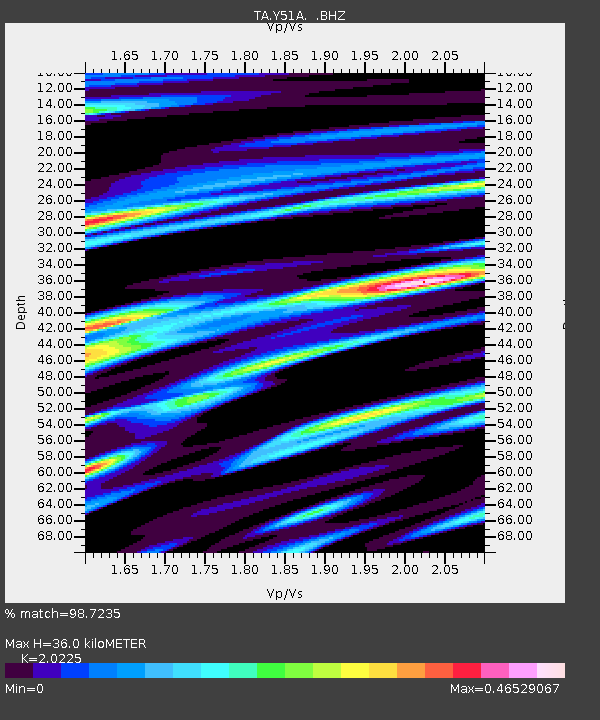
| Estimated Moho Depth: |
36.0 km |
| Estimated Crust Vp/Vs: |
2.02 |
| Assumed Crust Vp: |
6.719 km/s |
| Estimated Crust Vs: |
3.322 km/s |
| Estimated Crust Poisson's Ratio: |
0.34 |
|
| Radial Match: |
98.7235 % |
| Radial Bump: |
365 |
| Transverse Match: |
96.32245 % |
| Transverse Bump: |
400 |
| SOD ConfigId: |
512894 |
| Insert Time: |
2013-09-14 17:53:31.504 +0000 |
| GWidth: |
2.5 |
| Max Bumps: |
400 |
| Tol: |
0.001 |
|
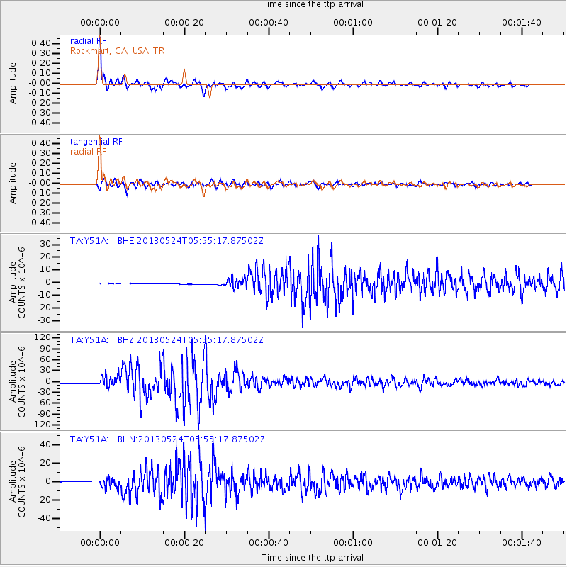
Signal To Noise
| Channel | StoN | STA | LTA |
| TA:Y51A: :BHZ:20130524T05:55:17.87502Z | 14.235349 | 1.5275416E-5 | 1.0730624E-6 |
| TA:Y51A: :BHN:20130524T05:55:17.87502Z | 11.99916 | 5.0574536E-6 | 4.2148397E-7 |
| TA:Y51A: :BHE:20130524T05:55:17.87502Z | 11.954331 | 3.549525E-6 | 2.9692376E-7 |
| Arrivals |
| Ps | 5.6 SECOND |
| PpPs | 16 SECOND |
| PsPs/PpSs | 21 SECOND |


