You are here: Home > Network List > YB13 - Continental Dynamics/Cent. Anatolian Tectonics:Surface to Mantle Dynamics During Stations List
> Station AT54 "Alpu,Pozanti",Adana,Turkey > Earthquake Result Viewer
AT54 "Alpu,Pozanti",Adana,Turkey - Earthquake Result Viewer
| Earthquake location: |
Hokkaido, Japan Region |
| Earthquake latitude/longitude: |
41.1/142.2 |
| Earthquake time(UTC): |
2014/08/10 (222) 03:43:16 GMT |
| Earthquake Depth: |
38 km |
| Earthquake Magnitude: |
6.0 MB |
| Earthquake Catalog/Contributor: |
NEIC PDE/NEIC COMCAT |
|
| Network: |
YB Continental Dynamics/Cent. Anatolian Tectonics:Surface to Mantle Dynamics During |
| Station: |
AT54 "Alpu,Pozanti",Adana,Turkey |
| Lat/Lon: |
37.48 N/34.88 E |
| Elevation: |
1154 m |
|
| Distance: |
77.4 deg |
| Az: |
308.881 deg |
| Baz: |
47.647 deg |
| Ray Param: |
0.050305054 |
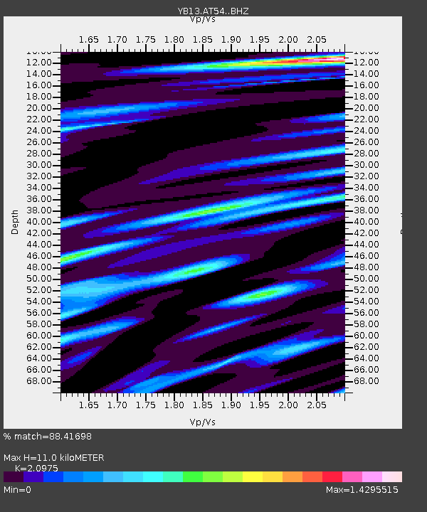
| Estimated Moho Depth: |
11.0 km |
| Estimated Crust Vp/Vs: |
2.10 |
| Assumed Crust Vp: |
6.247 km/s |
| Estimated Crust Vs: |
2.978 km/s |
| Estimated Crust Poisson's Ratio: |
0.35 |
|
| Radial Match: |
88.41698 % |
| Radial Bump: |
400 |
| Transverse Match: |
85.502686 % |
| Transverse Bump: |
400 |
| SOD ConfigId: |
3390531 |
| Insert Time: |
2019-04-13 06:51:28.521 +0000 |
| GWidth: |
2.5 |
| Max Bumps: |
400 |
| Tol: |
0.001 |
|

Signal To Noise
| Channel | StoN | STA | LTA |
| YB:AT54: :BHZ:20140810T03:54:37.099993Z | 49.982635 | 2.3749953E-6 | 4.751641E-8 |
| YB:AT54: :BHN:20140810T03:54:37.099993Z | 7.153214 | 6.004866E-7 | 8.3946404E-8 |
| YB:AT54: :BHE:20140810T03:54:37.099993Z | 5.019071 | 5.938645E-7 | 1.183216E-7 |
| Arrivals |
| Ps | 2.0 SECOND |
| PpPs | 5.3 SECOND |
| PsPs/PpSs | 7.3 SECOND |


