You are here: Home > Network List > TA - USArray Transportable Network (new EarthScope stations) Stations List
> Station Y57A Sumter, SC, USA > Earthquake Result Viewer
Y57A Sumter, SC, USA - Earthquake Result Viewer
| Earthquake location: |
Sea Of Okhotsk |
| Earthquake latitude/longitude: |
54.9/153.2 |
| Earthquake time(UTC): |
2013/05/24 (144) 05:44:48 GMT |
| Earthquake Depth: |
598 km |
| Earthquake Magnitude: |
8.4 MW, 7.5 MB, 8.3 MW |
| Earthquake Catalog/Contributor: |
NEIC PDE/NEIC PDE-W |
|
| Network: |
TA USArray Transportable Network (new EarthScope stations) |
| Station: |
Y57A Sumter, SC, USA |
| Lat/Lon: |
34.02 N/80.39 W |
| Elevation: |
56 m |
|
| Distance: |
80.2 deg |
| Az: |
42.728 deg |
| Baz: |
331.841 deg |
| Ray Param: |
0.046581484 |
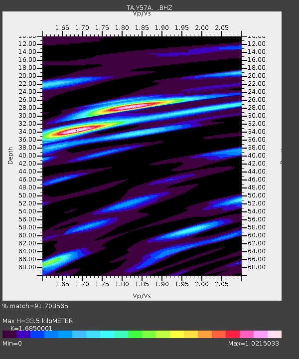
| Estimated Moho Depth: |
33.5 km |
| Estimated Crust Vp/Vs: |
1.69 |
| Assumed Crust Vp: |
6.419 km/s |
| Estimated Crust Vs: |
3.81 km/s |
| Estimated Crust Poisson's Ratio: |
0.23 |
|
| Radial Match: |
91.708565 % |
| Radial Bump: |
400 |
| Transverse Match: |
74.97811 % |
| Transverse Bump: |
400 |
| SOD ConfigId: |
512894 |
| Insert Time: |
2013-09-14 17:53:47.674 +0000 |
| GWidth: |
2.5 |
| Max Bumps: |
400 |
| Tol: |
0.001 |
|
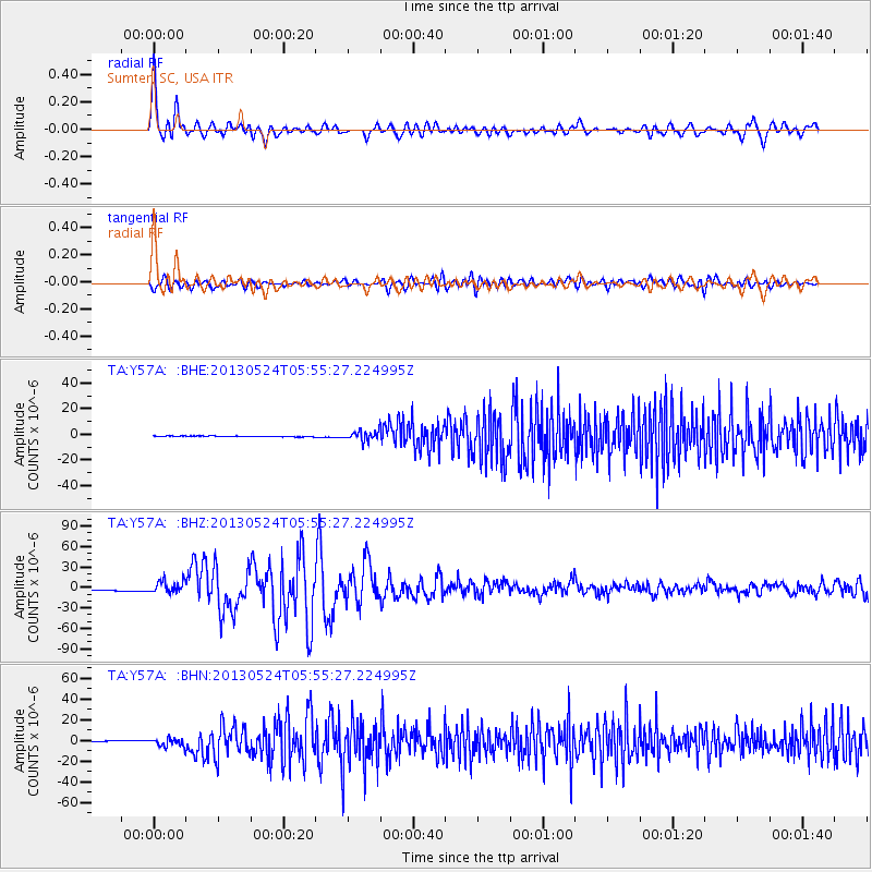
Signal To Noise
| Channel | StoN | STA | LTA |
| TA:Y57A: :BHZ:20130524T05:55:27.224995Z | 8.89475 | 9.117332E-6 | 1.0250241E-6 |
| TA:Y57A: :BHN:20130524T05:55:27.224995Z | 8.03402 | 3.708779E-6 | 4.6163427E-7 |
| TA:Y57A: :BHE:20130524T05:55:27.224995Z | 12.121096 | 3.5615765E-6 | 2.9383287E-7 |
| Arrivals |
| Ps | 3.7 SECOND |
| PpPs | 14 SECOND |
| PsPs/PpSs | 17 SECOND |


