You are here: Home > Network List > TA - USArray Transportable Network (new EarthScope stations) Stations List
> Station Y60A Bolivia, NC, USA > Earthquake Result Viewer
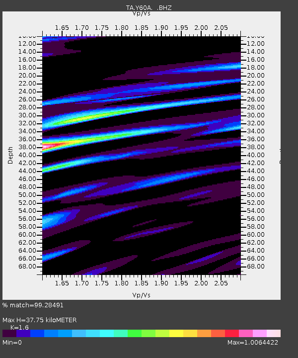
Y60A Bolivia, NC, USA - Earthquake Result Viewer
| Earthquake location: |
Sea Of Okhotsk |
| Earthquake latitude/longitude: |
54.9/153.2 |
| Earthquake time(UTC): |
2013/05/24 (144) 05:44:48 GMT |
| Earthquake Depth: |
598 km |
| Earthquake Magnitude: |
8.4 MW, 7.5 MB, 8.3 MW |
| Earthquake Catalog/Contributor: |
NEIC PDE/NEIC PDE-W |
|
| Network: |
TA USArray Transportable Network (new EarthScope stations) |
| Station: |
Y60A Bolivia, NC, USA |
| Lat/Lon: |
34.00 N/78.22 W |
| Elevation: |
7.0 m |
|
| Distance: |
81.1 deg |
| Az: |
41.112 deg |
| Baz: |
332.789 deg |
| Ray Param: |
0.046009976 |
| Estimated Moho Depth: |
37.75 km |
| Estimated Crust Vp/Vs: |
1.60 |
| Assumed Crust Vp: |
6.565 km/s |
| Estimated Crust Vs: |
4.103 km/s |
| Estimated Crust Poisson's Ratio: |
0.18 |
|
| Radial Match: |
99.28491 % |
| Radial Bump: |
400 |
| Transverse Match: |
98.09351 % |
| Transverse Bump: |
400 |
| SOD ConfigId: |
512894 |
| Insert Time: |
2013-09-14 17:53:53.007 +0000 |
| GWidth: |
2.5 |
| Max Bumps: |
400 |
| Tol: |
0.001 |
|

Signal To Noise
| Channel | StoN | STA | LTA |
| TA:Y60A: :BHZ:20130524T05:55:31.599995Z | 22.389236 | 1.8321089E-5 | 8.1829893E-7 |
| TA:Y60A: :BHN:20130524T05:55:31.599995Z | 4.2887497 | 4.034294E-6 | 9.40669E-7 |
| TA:Y60A: :BHE:20130524T05:55:31.599995Z | 6.727896 | 3.9650618E-6 | 5.893465E-7 |
| Arrivals |
| Ps | 3.6 SECOND |
| PpPs | 15 SECOND |
| PsPs/PpSs | 18 SECOND |


