You are here: Home > Network List > TA - USArray Transportable Network (new EarthScope stations) Stations List
> Station Z53A Monticello, GA, USA > Earthquake Result Viewer
Z53A Monticello, GA, USA - Earthquake Result Viewer
| Earthquake location: |
Sea Of Okhotsk |
| Earthquake latitude/longitude: |
54.9/153.2 |
| Earthquake time(UTC): |
2013/05/24 (144) 05:44:48 GMT |
| Earthquake Depth: |
598 km |
| Earthquake Magnitude: |
8.4 MW, 7.5 MB, 8.3 MW |
| Earthquake Catalog/Contributor: |
NEIC PDE/NEIC PDE-W |
|
| Network: |
TA USArray Transportable Network (new EarthScope stations) |
| Station: |
Z53A Monticello, GA, USA |
| Lat/Lon: |
33.28 N/83.57 W |
| Elevation: |
144 m |
|
| Distance: |
79.6 deg |
| Az: |
45.448 deg |
| Baz: |
330.564 deg |
| Ray Param: |
0.047000904 |
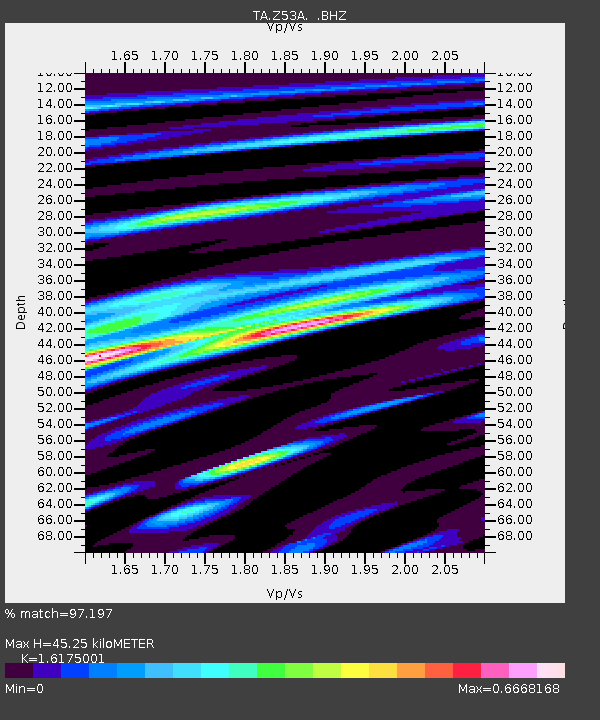
| Estimated Moho Depth: |
45.25 km |
| Estimated Crust Vp/Vs: |
1.62 |
| Assumed Crust Vp: |
6.565 km/s |
| Estimated Crust Vs: |
4.058 km/s |
| Estimated Crust Poisson's Ratio: |
0.19 |
|
| Radial Match: |
97.197 % |
| Radial Bump: |
400 |
| Transverse Match: |
92.78916 % |
| Transverse Bump: |
400 |
| SOD ConfigId: |
512894 |
| Insert Time: |
2013-09-14 17:54:10.673 +0000 |
| GWidth: |
2.5 |
| Max Bumps: |
400 |
| Tol: |
0.001 |
|

Signal To Noise
| Channel | StoN | STA | LTA |
| TA:Z53A: :BHZ:20130524T05:55:23.948994Z | 10.775677 | 1.0346304E-5 | 9.601536E-7 |
| TA:Z53A: :BHN:20130524T05:55:23.948994Z | 8.439029 | 2.9932046E-6 | 3.5468588E-7 |
| TA:Z53A: :BHE:20130524T05:55:23.948994Z | 7.606834 | 2.3577509E-6 | 3.0995164E-7 |
| Arrivals |
| Ps | 4.4 SECOND |
| PpPs | 18 SECOND |
| PsPs/PpSs | 22 SECOND |


