You are here: Home > Network List > US - United States National Seismic Network Stations List
> Station DGMT Dagmar, Montana, USA > Earthquake Result Viewer
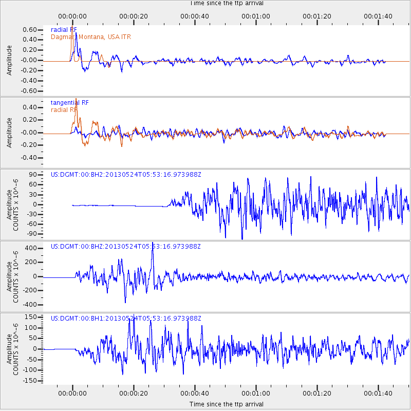
DGMT Dagmar, Montana, USA - Earthquake Result Viewer
*The percent match for this event was below the threshold and hence no stack was calculated.
| Earthquake location: |
Sea Of Okhotsk |
| Earthquake latitude/longitude: |
54.9/153.2 |
| Earthquake time(UTC): |
2013/05/24 (144) 05:44:48 GMT |
| Earthquake Depth: |
598 km |
| Earthquake Magnitude: |
8.4 MW, 7.5 MB, 8.3 MW |
| Earthquake Catalog/Contributor: |
NEIC PDE/NEIC PDE-W |
|
| Network: |
US United States National Seismic Network |
| Station: |
DGMT Dagmar, Montana, USA |
| Lat/Lon: |
48.47 N/104.20 W |
| Elevation: |
0.0 m |
|
| Distance: |
58.3 deg |
| Az: |
49.766 deg |
| Baz: |
318.494 deg |
| Ray Param: |
$rayparam |
*The percent match for this event was below the threshold and hence was not used in the summary stack. |
|
| Radial Match: |
95.33296 % |
| Radial Bump: |
400 |
| Transverse Match: |
89.0622 % |
| Transverse Bump: |
400 |
| SOD ConfigId: |
512894 |
| Insert Time: |
2013-09-14 17:55:43.609 +0000 |
| GWidth: |
2.5 |
| Max Bumps: |
400 |
| Tol: |
0.001 |
|
Signal To Noise
| Channel | StoN | STA | LTA |
| US:DGMT:00:BHZ:20130524T05:53:16.973988Z | 16.947756 | 3.8106205E-5 | 2.2484514E-6 |
| US:DGMT:00:BH1:20130524T05:53:16.973988Z | 10.493555 | 1.1569045E-5 | 1.1024905E-6 |
| US:DGMT:00:BH2:20130524T05:53:16.973988Z | 8.348704 | 7.0664123E-6 | 8.464082E-7 |
| Arrivals |
| Ps | |
| PpPs | |
| PsPs/PpSs | |


