You are here: Home > Network List > US - United States National Seismic Network Stations List
> Station ELK Elko, Nevada, USA > Earthquake Result Viewer
ELK Elko, Nevada, USA - Earthquake Result Viewer
| Earthquake location: |
Sea Of Okhotsk |
| Earthquake latitude/longitude: |
54.9/153.2 |
| Earthquake time(UTC): |
2013/05/24 (144) 05:44:48 GMT |
| Earthquake Depth: |
598 km |
| Earthquake Magnitude: |
8.4 MW, 7.5 MB, 8.3 MW |
| Earthquake Catalog/Contributor: |
NEIC PDE/NEIC PDE-W |
|
| Network: |
US United States National Seismic Network |
| Station: |
ELK Elko, Nevada, USA |
| Lat/Lon: |
40.74 N/115.24 W |
| Elevation: |
2210 m |
|
| Distance: |
58.7 deg |
| Az: |
62.684 deg |
| Baz: |
317.502 deg |
| Ray Param: |
0.06018561 |
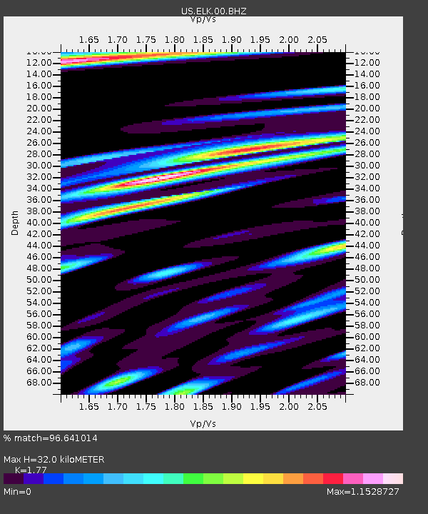
| Estimated Moho Depth: |
32.0 km |
| Estimated Crust Vp/Vs: |
1.77 |
| Assumed Crust Vp: |
6.276 km/s |
| Estimated Crust Vs: |
3.546 km/s |
| Estimated Crust Poisson's Ratio: |
0.27 |
|
| Radial Match: |
96.641014 % |
| Radial Bump: |
400 |
| Transverse Match: |
95.684265 % |
| Transverse Bump: |
400 |
| SOD ConfigId: |
512894 |
| Insert Time: |
2013-09-14 17:55:51.585 +0000 |
| GWidth: |
2.5 |
| Max Bumps: |
400 |
| Tol: |
0.001 |
|

Signal To Noise
| Channel | StoN | STA | LTA |
| US:ELK:00:BHZ:20130524T05:53:19.924Z | 7.8861804 | 2.2393167E-5 | 2.8395452E-6 |
| US:ELK:00:BH1:20130524T05:53:19.924Z | 6.8357325 | 8.178226E-6 | 1.1963936E-6 |
| US:ELK:00:BH2:20130524T05:53:19.924Z | 6.933577 | 7.805127E-6 | 1.1256999E-6 |
| Arrivals |
| Ps | 4.1 SECOND |
| PpPs | 14 SECOND |
| PsPs/PpSs | 18 SECOND |


