You are here: Home > Network List > US - United States National Seismic Network Stations List
> Station SDCO Great Sand Dunes National Park, Colorado, USA > Earthquake Result Viewer
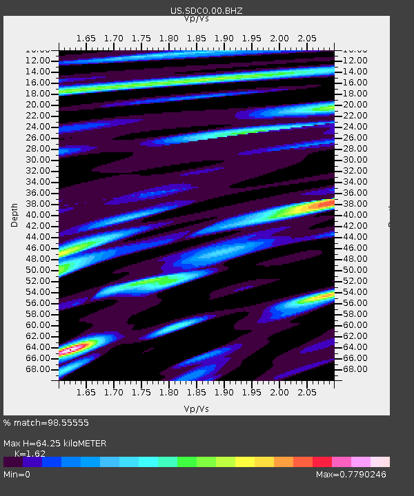
SDCO Great Sand Dunes National Park, Colorado, USA - Earthquake Result Viewer
| Earthquake location: |
Sea Of Okhotsk |
| Earthquake latitude/longitude: |
54.9/153.2 |
| Earthquake time(UTC): |
2013/05/24 (144) 05:44:48 GMT |
| Earthquake Depth: |
598 km |
| Earthquake Magnitude: |
8.4 MW, 7.5 MB, 8.3 MW |
| Earthquake Catalog/Contributor: |
NEIC PDE/NEIC PDE-W |
|
| Network: |
US United States National Seismic Network |
| Station: |
SDCO Great Sand Dunes National Park, Colorado, USA |
| Lat/Lon: |
37.75 N/105.50 W |
| Elevation: |
2569 m |
|
| Distance: |
65.9 deg |
| Az: |
58.377 deg |
| Baz: |
321.644 deg |
| Ray Param: |
0.055749148 |
| Estimated Moho Depth: |
64.25 km |
| Estimated Crust Vp/Vs: |
1.62 |
| Assumed Crust Vp: |
6.316 km/s |
| Estimated Crust Vs: |
3.898 km/s |
| Estimated Crust Poisson's Ratio: |
0.19 |
|
| Radial Match: |
98.55555 % |
| Radial Bump: |
400 |
| Transverse Match: |
96.96822 % |
| Transverse Bump: |
400 |
| SOD ConfigId: |
512894 |
| Insert Time: |
2013-09-14 17:57:11.171 +0000 |
| GWidth: |
2.5 |
| Max Bumps: |
400 |
| Tol: |
0.001 |
|

Signal To Noise
| Channel | StoN | STA | LTA |
| US:SDCO:00:BHZ:20130524T05:54:06.04897Z | 8.943804 | 1.890196E-5 | 2.113414E-6 |
| US:SDCO:00:BH1:20130524T05:54:06.04897Z | 8.114829 | 4.472963E-6 | 5.512086E-7 |
| US:SDCO:00:BH2:20130524T05:54:06.04897Z | 6.443685 | 5.7446186E-6 | 8.915114E-7 |
| Arrivals |
| Ps | 6.6 SECOND |
| PpPs | 26 SECOND |
| PsPs/PpSs | 32 SECOND |


