You are here: Home > Network List > US - United States National Seismic Network Stations List
> Station WMOK Wichita Mountains, Oklahoma, USA > Earthquake Result Viewer
WMOK Wichita Mountains, Oklahoma, USA - Earthquake Result Viewer

| Earthquake location: |
Sea Of Okhotsk |
| Earthquake latitude/longitude: |
54.9/153.2 |
| Earthquake time(UTC): |
2013/05/24 (144) 05:44:48 GMT |
| Earthquake Depth: |
598 km |
| Earthquake Magnitude: |
8.4 MW, 7.5 MB, 8.3 MW |
| Earthquake Catalog/Contributor: |
NEIC PDE/NEIC PDE-W |
|
| Network: |
US United States National Seismic Network |
| Station: |
WMOK Wichita Mountains, Oklahoma, USA |
| Lat/Lon: |
34.74 N/98.78 W |
| Elevation: |
486 m |
|
| Distance: |
71.6 deg |
| Az: |
55.645 deg |
| Baz: |
324.612 deg |
| Ray Param: |
0.052187987 |
| Estimated Moho Depth: |
28.75 km |
| Estimated Crust Vp/Vs: |
1.60 |
| Assumed Crust Vp: |
6.315 km/s |
| Estimated Crust Vs: |
3.947 km/s |
| Estimated Crust Poisson's Ratio: |
0.18 |
|
| Radial Match: |
98.529854 % |
| Radial Bump: |
400 |
| Transverse Match: |
96.89993 % |
| Transverse Bump: |
400 |
| SOD ConfigId: |
512894 |
| Insert Time: |
2013-09-14 17:57:21.066 +0000 |
| GWidth: |
2.5 |
| Max Bumps: |
400 |
| Tol: |
0.001 |
|
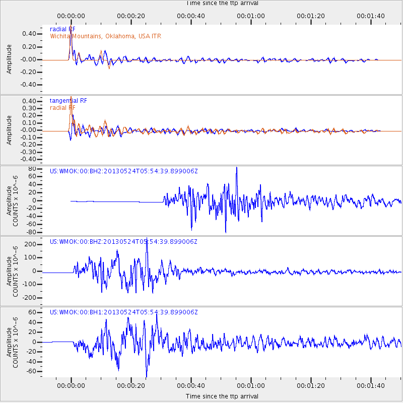
Signal To Noise
| Channel | StoN | STA | LTA |
| US:WMOK:00:BHZ:20130524T05:54:39.899006Z | 14.406857 | 2.5243991E-5 | 1.7522206E-6 |
| US:WMOK:00:BH1:20130524T05:54:39.899006Z | 9.204422 | 6.762508E-6 | 7.347021E-7 |
| US:WMOK:00:BH2:20130524T05:54:39.899006Z | 16.072332 | 7.488453E-6 | 4.6592197E-7 |
| Arrivals |
| Ps | 2.8 SECOND |
| PpPs | 11 SECOND |
| PsPs/PpSs | 14 SECOND |


