You are here: Home > Network List > TA - USArray Transportable Network (new EarthScope stations) Stations List
> Station X43A Marvell, AR, USA > Earthquake Result Viewer
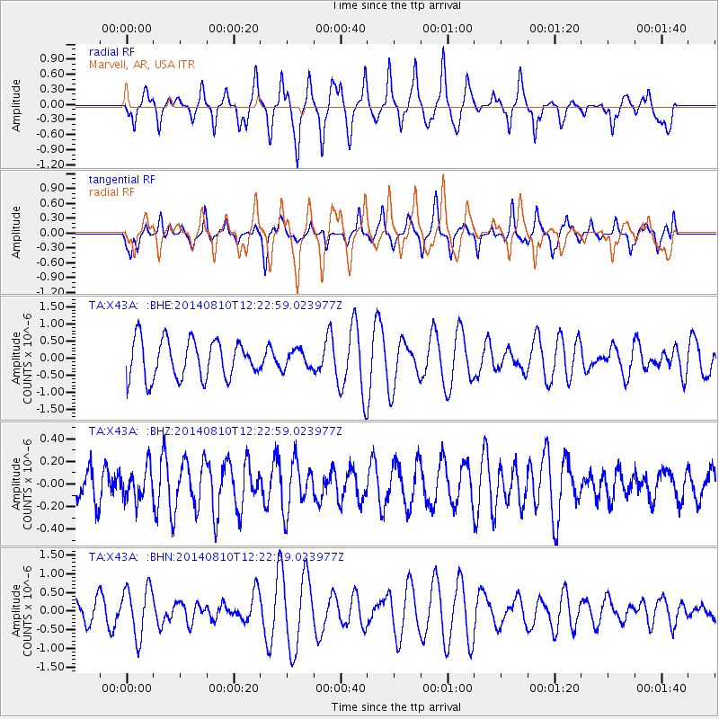
X43A Marvell, AR, USA - Earthquake Result Viewer
*The percent match for this event was below the threshold and hence no stack was calculated.
| Earthquake location: |
Central Mid-Atlantic Ridge |
| Earthquake latitude/longitude: |
0.7/-26.0 |
| Earthquake time(UTC): |
2014/08/10 (222) 12:12:24 GMT |
| Earthquake Depth: |
10 km |
| Earthquake Magnitude: |
5.1 MW, 5.0 mb |
| Earthquake Catalog/Contributor: |
ISC/ISC |
|
| Network: |
TA USArray Transportable Network (new EarthScope stations) |
| Station: |
X43A Marvell, AR, USA |
| Lat/Lon: |
34.52 N/90.88 W |
| Elevation: |
53 m |
|
| Distance: |
69.0 deg |
| Az: |
306.819 deg |
| Baz: |
104.206 deg |
| Ray Param: |
$rayparam |
*The percent match for this event was below the threshold and hence was not used in the summary stack. |
|
| Radial Match: |
76.75333 % |
| Radial Bump: |
400 |
| Transverse Match: |
48.96261 % |
| Transverse Bump: |
319 |
| SOD ConfigId: |
3390531 |
| Insert Time: |
2019-04-13 06:59:02.205 +0000 |
| GWidth: |
2.5 |
| Max Bumps: |
400 |
| Tol: |
0.001 |
|
Signal To Noise
| Channel | StoN | STA | LTA |
| TA:X43A: :BHZ:20140810T12:22:59.023977Z | 0.6720068 | 1.4087665E-7 | 2.0963576E-7 |
| TA:X43A: :BHN:20140810T12:22:59.023977Z | 2.1944113 | 6.692294E-7 | 3.049699E-7 |
| TA:X43A: :BHE:20140810T12:22:59.023977Z | 0.4826323 | 2.6891848E-7 | 5.5719124E-7 |
| Arrivals |
| Ps | |
| PpPs | |
| PsPs/PpSs | |


