You are here: Home > Network List > US - United States National Seismic Network Stations List
> Station WMOK Wichita Mountains, Oklahoma, USA > Earthquake Result Viewer
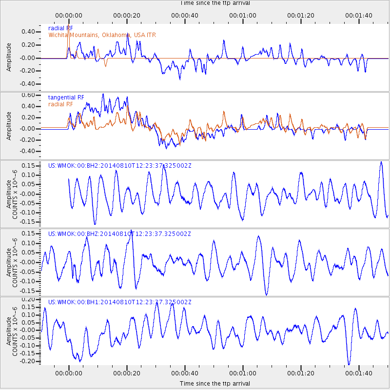
WMOK Wichita Mountains, Oklahoma, USA - Earthquake Result Viewer
*The percent match for this event was below the threshold and hence no stack was calculated.
| Earthquake location: |
Central Mid-Atlantic Ridge |
| Earthquake latitude/longitude: |
0.7/-26.0 |
| Earthquake time(UTC): |
2014/08/10 (222) 12:12:24 GMT |
| Earthquake Depth: |
10 km |
| Earthquake Magnitude: |
5.1 MW, 5.0 mb |
| Earthquake Catalog/Contributor: |
ISC/ISC |
|
| Network: |
US United States National Seismic Network |
| Station: |
WMOK Wichita Mountains, Oklahoma, USA |
| Lat/Lon: |
34.74 N/98.78 W |
| Elevation: |
486 m |
|
| Distance: |
75.4 deg |
| Az: |
305.647 deg |
| Baz: |
99.374 deg |
| Ray Param: |
$rayparam |
*The percent match for this event was below the threshold and hence was not used in the summary stack. |
|
| Radial Match: |
57.614624 % |
| Radial Bump: |
400 |
| Transverse Match: |
55.575405 % |
| Transverse Bump: |
400 |
| SOD ConfigId: |
3390531 |
| Insert Time: |
2019-04-13 06:59:32.925 +0000 |
| GWidth: |
2.5 |
| Max Bumps: |
400 |
| Tol: |
0.001 |
|
Signal To Noise
| Channel | StoN | STA | LTA |
| US:WMOK:00:BHZ:20140810T12:23:37.325002Z | 0.58602744 | 5.6254912E-8 | 9.599365E-8 |
| US:WMOK:00:BH1:20140810T12:23:37.325002Z | 2.843748 | 2.0285412E-7 | 7.133336E-8 |
| US:WMOK:00:BH2:20140810T12:23:37.325002Z | 1.2099375 | 7.922757E-8 | 6.548071E-8 |
| Arrivals |
| Ps | |
| PpPs | |
| PsPs/PpSs | |


