You are here: Home > Network List > AK - Alaska Regional Network Stations List
> Station KNK Knik Glacier, AK, USA > Earthquake Result Viewer
KNK Knik Glacier, AK, USA - Earthquake Result Viewer
| Earthquake location: |
Sea Of Okhotsk |
| Earthquake latitude/longitude: |
53.0/153.0 |
| Earthquake time(UTC): |
2013/05/24 (144) 06:03:07 GMT |
| Earthquake Depth: |
514 km |
| Earthquake Magnitude: |
5.5 MB |
| Earthquake Catalog/Contributor: |
NEIC PDE/NEIC PDE-W |
|
| Network: |
AK Alaska Regional Network |
| Station: |
KNK Knik Glacier, AK, USA |
| Lat/Lon: |
61.41 N/148.46 W |
| Elevation: |
601 m |
|
| Distance: |
31.8 deg |
| Az: |
51.228 deg |
| Baz: |
281.732 deg |
| Ray Param: |
0.076726206 |
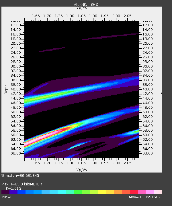
| Estimated Moho Depth: |
63.0 km |
| Estimated Crust Vp/Vs: |
1.62 |
| Assumed Crust Vp: |
6.566 km/s |
| Estimated Crust Vs: |
4.066 km/s |
| Estimated Crust Poisson's Ratio: |
0.19 |
|
| Radial Match: |
89.581345 % |
| Radial Bump: |
400 |
| Transverse Match: |
61.35792 % |
| Transverse Bump: |
280 |
| SOD ConfigId: |
512894 |
| Insert Time: |
2013-09-14 18:03:26.771 +0000 |
| GWidth: |
2.5 |
| Max Bumps: |
400 |
| Tol: |
0.001 |
|

Signal To Noise
| Channel | StoN | STA | LTA |
| AK:KNK: :BHZ:20130524T06:08:18.727997Z | 0.4709877 | 6.472071E-5 | 1.3741487E-4 |
| AK:KNK: :BHN:20130524T06:08:18.727997Z | 1.9403062 | 1.5055986E-4 | 7.7595934E-5 |
| AK:KNK: :BHE:20130524T06:08:18.727997Z | 0.56926 | 7.313487E-5 | 1.2847358E-4 |
| Arrivals |
| Ps | 6.4 SECOND |
| PpPs | 23 SECOND |
| PsPs/PpSs | 29 SECOND |


