You are here: Home > Network List > KN - Kyrgyz Seismic Telemetry Network Stations List
> Station TKM2 - > Earthquake Result Viewer
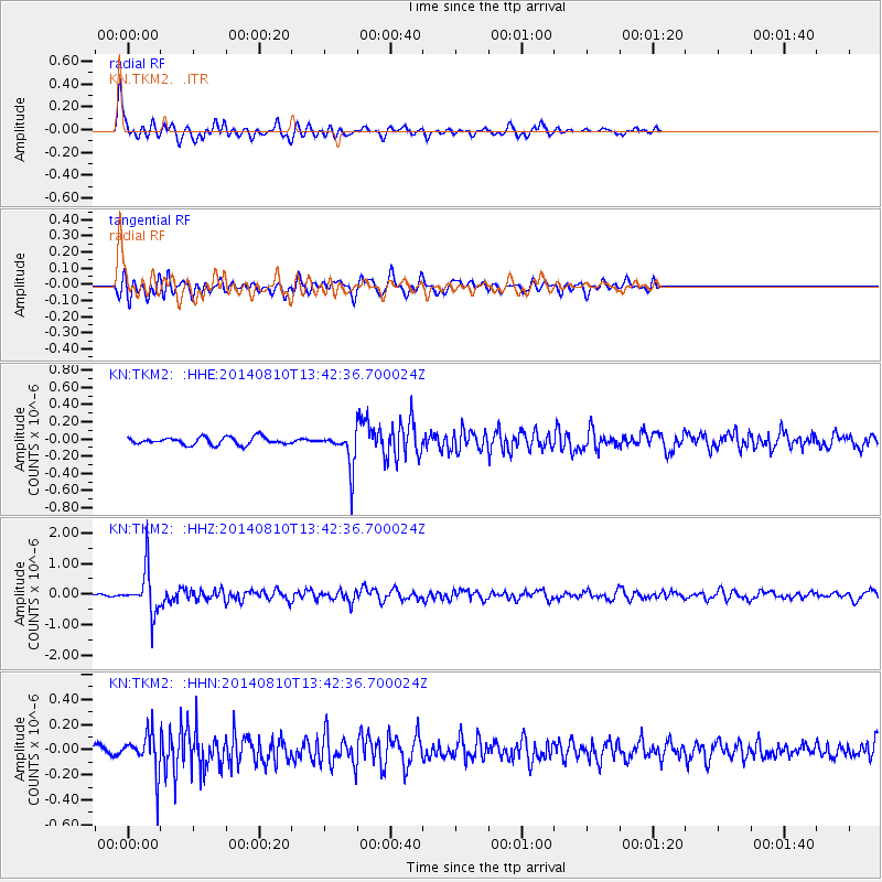
TKM2 - - Earthquake Result Viewer
*The percent match for this event was below the threshold and hence no stack was calculated.
| Earthquake location: |
Philippine Islands Region |
| Earthquake latitude/longitude: |
5.9/127.1 |
| Earthquake time(UTC): |
2014/08/10 (222) 13:33:22 GMT |
| Earthquake Depth: |
94 km |
| Earthquake Magnitude: |
5.6 MB |
| Earthquake Catalog/Contributor: |
NEIC PDE/NEIC COMCAT |
|
| Network: |
KN Kyrgyz Seismic Telemetry Network |
| Station: |
TKM2 - |
| Lat/Lon: |
42.92 N/75.60 E |
| Elevation: |
2020 m |
|
| Distance: |
58.4 deg |
| Az: |
317.535 deg |
| Baz: |
113.894 deg |
| Ray Param: |
$rayparam |
*The percent match for this event was below the threshold and hence was not used in the summary stack. |
|
| Radial Match: |
75.297874 % |
| Radial Bump: |
374 |
| Transverse Match: |
67.612885 % |
| Transverse Bump: |
400 |
| SOD ConfigId: |
3390531 |
| Insert Time: |
2019-04-13 07:04:36.414 +0000 |
| GWidth: |
2.5 |
| Max Bumps: |
400 |
| Tol: |
0.001 |
|
Signal To Noise
| Channel | StoN | STA | LTA |
| KN:TKM2: :HHZ:20140810T13:42:36.700024Z | 19.196499 | 7.1984E-7 | 3.7498506E-8 |
| KN:TKM2: :HHN:20140810T13:42:36.700024Z | 5.520058 | 1.5891122E-7 | 2.878796E-8 |
| KN:TKM2: :HHE:20140810T13:42:36.700024Z | 5.7137713 | 2.4712136E-7 | 4.3250132E-8 |
| Arrivals |
| Ps | |
| PpPs | |
| PsPs/PpSs | |


