You are here: Home > Network List > TA - USArray Transportable Network (new EarthScope stations) Stations List
> Station V60A Jim Taylor Road, Stokes, NC, USA > Earthquake Result Viewer
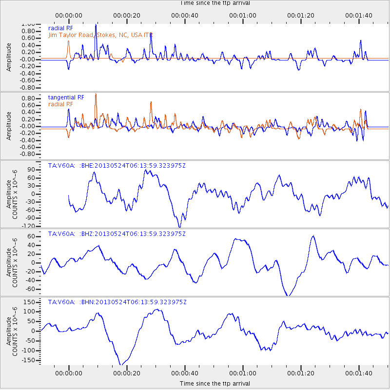
V60A Jim Taylor Road, Stokes, NC, USA - Earthquake Result Viewer
*The percent match for this event was below the threshold and hence no stack was calculated.
| Earthquake location: |
Sea Of Okhotsk |
| Earthquake latitude/longitude: |
53.0/153.0 |
| Earthquake time(UTC): |
2013/05/24 (144) 06:03:07 GMT |
| Earthquake Depth: |
514 km |
| Earthquake Magnitude: |
5.5 MB |
| Earthquake Catalog/Contributor: |
NEIC PDE/NEIC PDE-W |
|
| Network: |
TA USArray Transportable Network (new EarthScope stations) |
| Station: |
V60A Jim Taylor Road, Stokes, NC, USA |
| Lat/Lon: |
35.76 N/77.26 W |
| Elevation: |
8.0 m |
|
| Distance: |
81.4 deg |
| Az: |
39.233 deg |
| Baz: |
331.982 deg |
| Ray Param: |
$rayparam |
*The percent match for this event was below the threshold and hence was not used in the summary stack. |
|
| Radial Match: |
40.004284 % |
| Radial Bump: |
352 |
| Transverse Match: |
31.748714 % |
| Transverse Bump: |
400 |
| SOD ConfigId: |
512894 |
| Insert Time: |
2013-09-14 18:29:01.765 +0000 |
| GWidth: |
2.5 |
| Max Bumps: |
400 |
| Tol: |
0.001 |
|
Signal To Noise
| Channel | StoN | STA | LTA |
| TA:V60A: :BHZ:20130524T06:13:59.323975Z | 1.0739942 | 1.3319957E-5 | 1.2402263E-5 |
| TA:V60A: :BHN:20130524T06:13:59.323975Z | 0.5085476 | 1.6454165E-5 | 3.2355212E-5 |
| TA:V60A: :BHE:20130524T06:13:59.323975Z | 1.5199211 | 5.8237456E-5 | 3.8316106E-5 |
| Arrivals |
| Ps | |
| PpPs | |
| PsPs/PpSs | |


