You are here: Home > Network List > TA - USArray Transportable Network (new EarthScope stations) Stations List
> Station W50A Signal Mountain, TN, USA > Earthquake Result Viewer
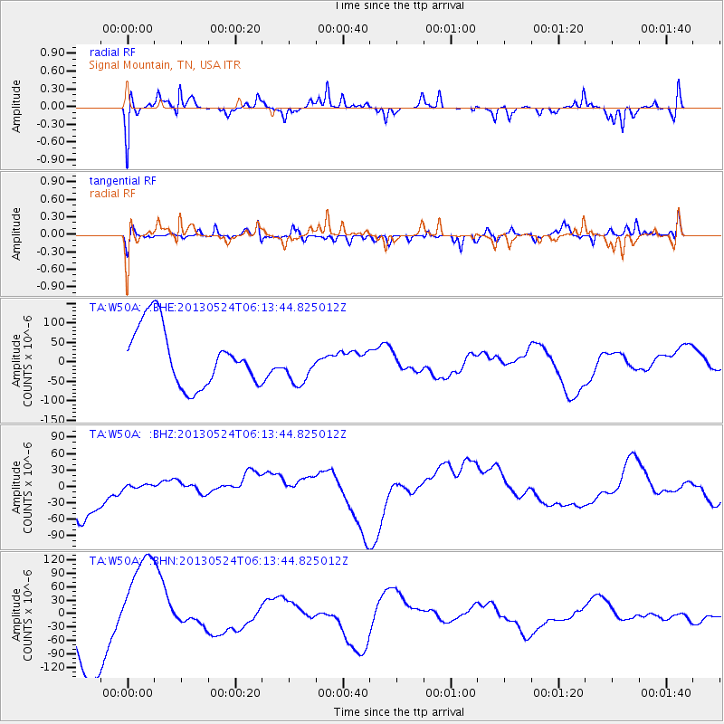
W50A Signal Mountain, TN, USA - Earthquake Result Viewer
*The percent match for this event was below the threshold and hence no stack was calculated.
| Earthquake location: |
Sea Of Okhotsk |
| Earthquake latitude/longitude: |
53.0/153.0 |
| Earthquake time(UTC): |
2013/05/24 (144) 06:03:07 GMT |
| Earthquake Depth: |
514 km |
| Earthquake Magnitude: |
5.5 MB |
| Earthquake Catalog/Contributor: |
NEIC PDE/NEIC PDE-W |
|
| Network: |
TA USArray Transportable Network (new EarthScope stations) |
| Station: |
W50A Signal Mountain, TN, USA |
| Lat/Lon: |
35.20 N/85.31 W |
| Elevation: |
587 m |
|
| Distance: |
78.6 deg |
| Az: |
45.302 deg |
| Baz: |
328.381 deg |
| Ray Param: |
$rayparam |
*The percent match for this event was below the threshold and hence was not used in the summary stack. |
|
| Radial Match: |
52.924866 % |
| Radial Bump: |
339 |
| Transverse Match: |
32.526756 % |
| Transverse Bump: |
306 |
| SOD ConfigId: |
512894 |
| Insert Time: |
2013-09-14 18:29:17.152 +0000 |
| GWidth: |
2.5 |
| Max Bumps: |
400 |
| Tol: |
0.001 |
|
Signal To Noise
| Channel | StoN | STA | LTA |
| TA:W50A: :BHZ:20130524T06:13:44.825012Z | 0.07831822 | 2.789022E-6 | 3.5611403E-5 |
| TA:W50A: :BHN:20130524T06:13:44.825012Z | 1.7394329 | 1.1256636E-4 | 6.4714404E-5 |
| TA:W50A: :BHE:20130524T06:13:44.825012Z | 0.70740217 | 5.304423E-5 | 7.498455E-5 |
| Arrivals |
| Ps | |
| PpPs | |
| PsPs/PpSs | |


