You are here: Home > Network List > YB13 - Continental Dynamics/Cent. Anatolian Tectonics:Surface to Mantle Dynamics During Stations List
> Station AT23 Ayvazhaci,Kayseri,Turkey > Earthquake Result Viewer
AT23 Ayvazhaci,Kayseri,Turkey - Earthquake Result Viewer
| Earthquake location: |
Philippine Islands Region |
| Earthquake latitude/longitude: |
5.9/127.1 |
| Earthquake time(UTC): |
2014/08/10 (222) 13:33:22 GMT |
| Earthquake Depth: |
94 km |
| Earthquake Magnitude: |
5.6 MB |
| Earthquake Catalog/Contributor: |
NEIC PDE/NEIC COMCAT |
|
| Network: |
YB Continental Dynamics/Cent. Anatolian Tectonics:Surface to Mantle Dynamics During |
| Station: |
AT23 Ayvazhaci,Kayseri,Turkey |
| Lat/Lon: |
38.36 N/35.55 E |
| Elevation: |
1530 m |
|
| Distance: |
87.6 deg |
| Az: |
308.14 deg |
| Baz: |
84.425 deg |
| Ray Param: |
0.04300273 |
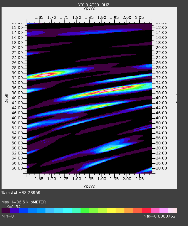
| Estimated Moho Depth: |
36.5 km |
| Estimated Crust Vp/Vs: |
1.94 |
| Assumed Crust Vp: |
6.35 km/s |
| Estimated Crust Vs: |
3.273 km/s |
| Estimated Crust Poisson's Ratio: |
0.32 |
|
| Radial Match: |
83.28959 % |
| Radial Bump: |
400 |
| Transverse Match: |
78.367775 % |
| Transverse Bump: |
400 |
| SOD ConfigId: |
3390531 |
| Insert Time: |
2019-04-13 07:05:53.383 +0000 |
| GWidth: |
2.5 |
| Max Bumps: |
400 |
| Tol: |
0.001 |
|

Signal To Noise
| Channel | StoN | STA | LTA |
| YB:AT23: :BHZ:20140810T13:45:28.440015Z | 18.127829 | 1.0559853E-6 | 5.8252166E-8 |
| YB:AT23: :BHN:20140810T13:45:28.440015Z | 1.3800746 | 1.2790238E-7 | 9.267787E-8 |
| YB:AT23: :BHE:20140810T13:45:28.440015Z | 3.4824226 | 1.5483205E-7 | 4.4461018E-8 |
| Arrivals |
| Ps | 5.5 SECOND |
| PpPs | 17 SECOND |
| PsPs/PpSs | 22 SECOND |


