You are here: Home > Network List > YB13 - Continental Dynamics/Cent. Anatolian Tectonics:Surface to Mantle Dynamics During Stations List
> Station AT24 Sarikaya,Kayseri,Turkey > Earthquake Result Viewer
AT24 Sarikaya,Kayseri,Turkey - Earthquake Result Viewer
| Earthquake location: |
Philippine Islands Region |
| Earthquake latitude/longitude: |
5.9/127.1 |
| Earthquake time(UTC): |
2014/08/10 (222) 13:33:22 GMT |
| Earthquake Depth: |
94 km |
| Earthquake Magnitude: |
5.6 MB |
| Earthquake Catalog/Contributor: |
NEIC PDE/NEIC COMCAT |
|
| Network: |
YB Continental Dynamics/Cent. Anatolian Tectonics:Surface to Mantle Dynamics During |
| Station: |
AT24 Sarikaya,Kayseri,Turkey |
| Lat/Lon: |
38.16 N/35.90 E |
| Elevation: |
1683 m |
|
| Distance: |
87.4 deg |
| Az: |
307.916 deg |
| Baz: |
84.632 deg |
| Ray Param: |
0.04319322 |
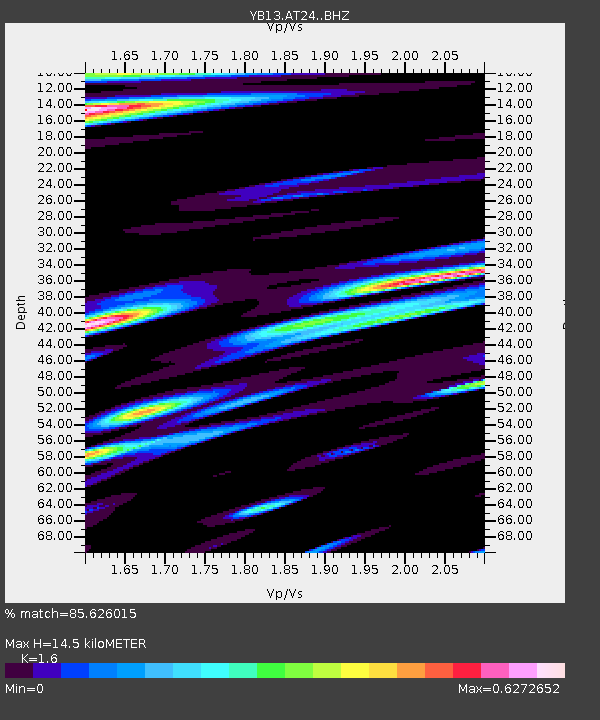
| Estimated Moho Depth: |
14.5 km |
| Estimated Crust Vp/Vs: |
1.60 |
| Assumed Crust Vp: |
6.35 km/s |
| Estimated Crust Vs: |
3.969 km/s |
| Estimated Crust Poisson's Ratio: |
0.18 |
|
| Radial Match: |
85.626015 % |
| Radial Bump: |
400 |
| Transverse Match: |
55.064877 % |
| Transverse Bump: |
400 |
| SOD ConfigId: |
3390531 |
| Insert Time: |
2019-04-13 07:05:53.596 +0000 |
| GWidth: |
2.5 |
| Max Bumps: |
400 |
| Tol: |
0.001 |
|

Signal To Noise
| Channel | StoN | STA | LTA |
| YB:AT24: :BHZ:20140810T13:45:27.200024Z | 22.108309 | 8.579384E-7 | 3.880615E-8 |
| YB:AT24: :BHN:20140810T13:45:27.200024Z | 0.7297268 | 9.2729124E-8 | 1.2707376E-7 |
| YB:AT24: :BHE:20140810T13:45:27.200024Z | 4.0256467 | 1.999718E-7 | 4.9674455E-8 |
| Arrivals |
| Ps | 1.4 SECOND |
| PpPs | 5.8 SECOND |
| PsPs/PpSs | 7.2 SECOND |


