You are here: Home > Network List > TA - USArray Transportable Network (new EarthScope stations) Stations List
> Station A04D Lummi Island, WA, USA > Earthquake Result Viewer
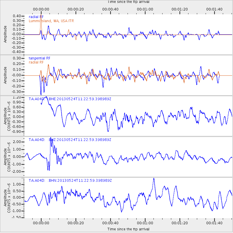
A04D Lummi Island, WA, USA - Earthquake Result Viewer
*The percent match for this event was below the threshold and hence no stack was calculated.
| Earthquake location: |
South Of Tonga Islands |
| Earthquake latitude/longitude: |
-24.3/-174.9 |
| Earthquake time(UTC): |
2013/05/24 (144) 11:10:48 GMT |
| Earthquake Depth: |
10 km |
| Earthquake Magnitude: |
5.8 MB, 5.9 MS |
| Earthquake Catalog/Contributor: |
NEIC PDE/NEIC PDE-W |
|
| Network: |
TA USArray Transportable Network (new EarthScope stations) |
| Station: |
A04D Lummi Island, WA, USA |
| Lat/Lon: |
48.72 N/122.71 W |
| Elevation: |
13 m |
|
| Distance: |
86.4 deg |
| Az: |
31.63 deg |
| Baz: |
226.25 deg |
| Ray Param: |
$rayparam |
*The percent match for this event was below the threshold and hence was not used in the summary stack. |
|
| Radial Match: |
53.4139 % |
| Radial Bump: |
400 |
| Transverse Match: |
53.055344 % |
| Transverse Bump: |
398 |
| SOD ConfigId: |
512894 |
| Insert Time: |
2013-09-14 18:48:08.017 +0000 |
| GWidth: |
2.5 |
| Max Bumps: |
400 |
| Tol: |
0.001 |
|
Signal To Noise
| Channel | StoN | STA | LTA |
| TA:A04D: :BHZ:20130524T11:22:59.398989Z | 1.0067611 | 8.686279E-7 | 8.6279454E-7 |
| TA:A04D: :BHN:20130524T11:22:59.398989Z | 1.1052402 | 3.9431046E-7 | 3.5676447E-7 |
| TA:A04D: :BHE:20130524T11:22:59.398989Z | 1.038903 | 5.2193184E-7 | 5.023875E-7 |
| Arrivals |
| Ps | |
| PpPs | |
| PsPs/PpSs | |


