You are here: Home > Network List > TA - USArray Transportable Network (new EarthScope stations) Stations List
> Station G05D Wamic, OR, USA > Earthquake Result Viewer
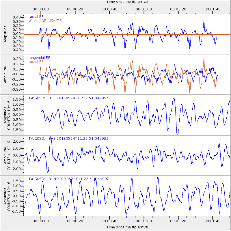
G05D Wamic, OR, USA - Earthquake Result Viewer
*The percent match for this event was below the threshold and hence no stack was calculated.
| Earthquake location: |
South Of Tonga Islands |
| Earthquake latitude/longitude: |
-24.3/-174.9 |
| Earthquake time(UTC): |
2013/05/24 (144) 11:10:48 GMT |
| Earthquake Depth: |
10 km |
| Earthquake Magnitude: |
5.8 MB, 5.9 MS |
| Earthquake Catalog/Contributor: |
NEIC PDE/NEIC PDE-W |
|
| Network: |
TA USArray Transportable Network (new EarthScope stations) |
| Station: |
G05D Wamic, OR, USA |
| Lat/Lon: |
45.24 N/121.32 W |
| Elevation: |
592 m |
|
| Distance: |
84.7 deg |
| Az: |
34.829 deg |
| Baz: |
227.512 deg |
| Ray Param: |
$rayparam |
*The percent match for this event was below the threshold and hence was not used in the summary stack. |
|
| Radial Match: |
60.476067 % |
| Radial Bump: |
359 |
| Transverse Match: |
42.02408 % |
| Transverse Bump: |
322 |
| SOD ConfigId: |
512894 |
| Insert Time: |
2013-09-14 18:48:36.028 +0000 |
| GWidth: |
2.5 |
| Max Bumps: |
400 |
| Tol: |
0.001 |
|
Signal To Noise
| Channel | StoN | STA | LTA |
| TA:G05D: :BHZ:20130524T11:22:51.04999Z | 2.675633 | 1.2148308E-6 | 4.5403493E-7 |
| TA:G05D: :BHN:20130524T11:22:51.04999Z | 1.3579136 | 1.0172761E-6 | 7.491464E-7 |
| TA:G05D: :BHE:20130524T11:22:51.04999Z | 1.0046769 | 4.884118E-7 | 4.861381E-7 |
| Arrivals |
| Ps | |
| PpPs | |
| PsPs/PpSs | |


