You are here: Home > Network List > TA - USArray Transportable Network (new EarthScope stations) Stations List
> Station J01E Myrtle Point, OR, USA > Earthquake Result Viewer
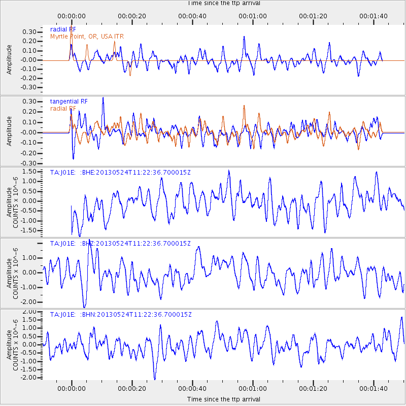
J01E Myrtle Point, OR, USA - Earthquake Result Viewer
*The percent match for this event was below the threshold and hence no stack was calculated.
| Earthquake location: |
South Of Tonga Islands |
| Earthquake latitude/longitude: |
-24.3/-174.9 |
| Earthquake time(UTC): |
2013/05/24 (144) 11:10:48 GMT |
| Earthquake Depth: |
10 km |
| Earthquake Magnitude: |
5.8 MB, 5.9 MS |
| Earthquake Catalog/Contributor: |
NEIC PDE/NEIC PDE-W |
|
| Network: |
TA USArray Transportable Network (new EarthScope stations) |
| Station: |
J01E Myrtle Point, OR, USA |
| Lat/Lon: |
43.16 N/123.93 W |
| Elevation: |
128 m |
|
| Distance: |
81.9 deg |
| Az: |
35.05 deg |
| Baz: |
225.72 deg |
| Ray Param: |
$rayparam |
*The percent match for this event was below the threshold and hence was not used in the summary stack. |
|
| Radial Match: |
56.391895 % |
| Radial Bump: |
400 |
| Transverse Match: |
49.37939 % |
| Transverse Bump: |
400 |
| SOD ConfigId: |
512894 |
| Insert Time: |
2013-09-14 18:48:55.328 +0000 |
| GWidth: |
2.5 |
| Max Bumps: |
400 |
| Tol: |
0.001 |
|
Signal To Noise
| Channel | StoN | STA | LTA |
| TA:J01E: :BHZ:20130524T11:22:36.700015Z | 1.2789774 | 1.0110725E-6 | 7.90532E-7 |
| TA:J01E: :BHN:20130524T11:22:36.700015Z | 0.51340175 | 4.4003002E-7 | 8.570872E-7 |
| TA:J01E: :BHE:20130524T11:22:36.700015Z | 1.2944134 | 7.746972E-7 | 5.984929E-7 |
| Arrivals |
| Ps | |
| PpPs | |
| PsPs/PpSs | |


