You are here: Home > Network List > TA - USArray Transportable Network (new EarthScope stations) Stations List
> Station M04C Macdoel, CA, USA > Earthquake Result Viewer
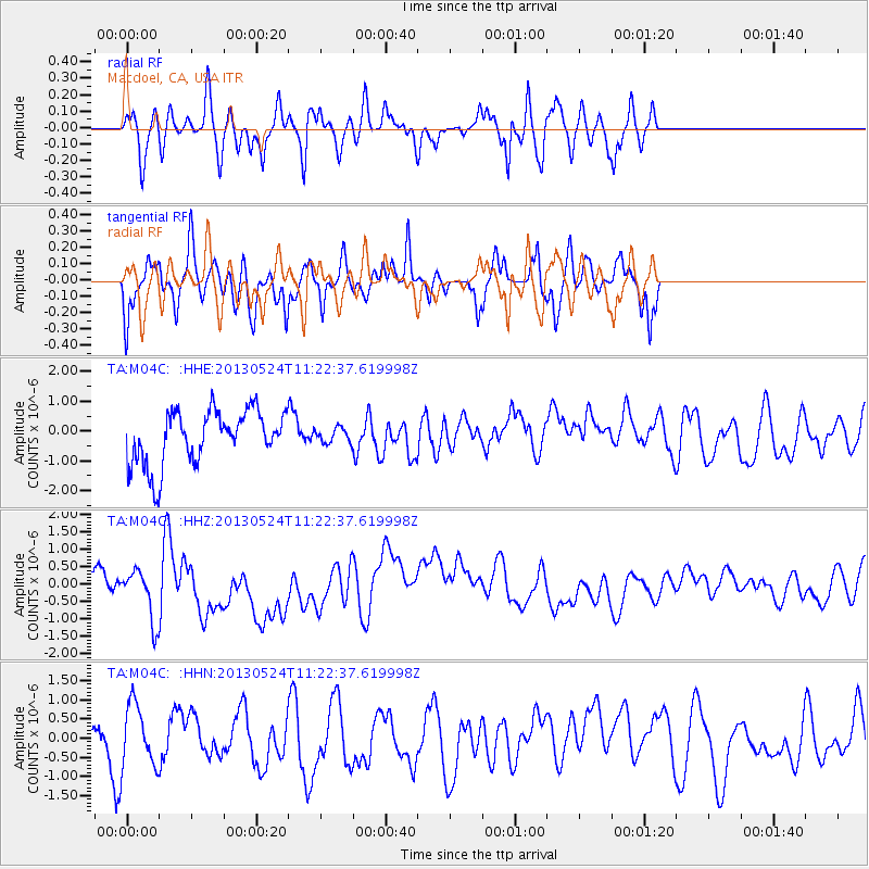
M04C Macdoel, CA, USA - Earthquake Result Viewer
*The percent match for this event was below the threshold and hence no stack was calculated.
| Earthquake location: |
South Of Tonga Islands |
| Earthquake latitude/longitude: |
-24.3/-174.9 |
| Earthquake time(UTC): |
2013/05/24 (144) 11:10:48 GMT |
| Earthquake Depth: |
10 km |
| Earthquake Magnitude: |
5.8 MB, 5.9 MS |
| Earthquake Catalog/Contributor: |
NEIC PDE/NEIC PDE-W |
|
| Network: |
TA USArray Transportable Network (new EarthScope stations) |
| Station: |
M04C Macdoel, CA, USA |
| Lat/Lon: |
41.78 N/121.84 W |
| Elevation: |
1391 m |
|
| Distance: |
82.1 deg |
| Az: |
37.136 deg |
| Baz: |
227.419 deg |
| Ray Param: |
$rayparam |
*The percent match for this event was below the threshold and hence was not used in the summary stack. |
|
| Radial Match: |
56.866135 % |
| Radial Bump: |
382 |
| Transverse Match: |
59.502632 % |
| Transverse Bump: |
309 |
| SOD ConfigId: |
512894 |
| Insert Time: |
2013-09-14 18:49:13.368 +0000 |
| GWidth: |
2.5 |
| Max Bumps: |
400 |
| Tol: |
0.001 |
|
Signal To Noise
| Channel | StoN | STA | LTA |
| TA:M04C: :HHZ:20130524T11:22:37.619998Z | 2.2803216 | 8.193904E-7 | 3.5933107E-7 |
| TA:M04C: :HHN:20130524T11:22:37.619998Z | 1.2181973 | 8.019918E-7 | 6.583431E-7 |
| TA:M04C: :HHE:20130524T11:22:37.619998Z | 0.27616 | 2.4687753E-7 | 8.9396565E-7 |
| Arrivals |
| Ps | |
| PpPs | |
| PsPs/PpSs | |


