You are here: Home > Network List > AG - Arkansas Seismic Network Stations List
> Station HHAR Hobbs,AR > Earthquake Result Viewer
HHAR Hobbs,AR - Earthquake Result Viewer
| Earthquake location: |
Sea Of Okhotsk |
| Earthquake latitude/longitude: |
52.2/151.4 |
| Earthquake time(UTC): |
2013/05/24 (144) 14:56:31 GMT |
| Earthquake Depth: |
624 km |
| Earthquake Magnitude: |
6.7 MW, 6.7 MB, 6.7 MW |
| Earthquake Catalog/Contributor: |
NEIC PDE/NEIC PDE-W |
|
| Network: |
AG Arkansas Seismic Network |
| Station: |
HHAR Hobbs,AR |
| Lat/Lon: |
36.28 N/93.94 W |
| Elevation: |
421 m |
|
| Distance: |
75.1 deg |
| Az: |
49.484 deg |
| Baz: |
324.646 deg |
| Ray Param: |
0.04984478 |
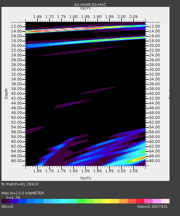
| Estimated Moho Depth: |
13.0 km |
| Estimated Crust Vp/Vs: |
1.76 |
| Assumed Crust Vp: |
6.53 km/s |
| Estimated Crust Vs: |
3.71 km/s |
| Estimated Crust Poisson's Ratio: |
0.26 |
|
| Radial Match: |
81.28433 % |
| Radial Bump: |
400 |
| Transverse Match: |
62.558193 % |
| Transverse Bump: |
400 |
| SOD ConfigId: |
512894 |
| Insert Time: |
2013-09-14 18:54:36.536 +0000 |
| GWidth: |
2.5 |
| Max Bumps: |
400 |
| Tol: |
0.001 |
|

Signal To Noise
| Channel | StoN | STA | LTA |
| AG:HHAR:00:HHZ:20130524T15:06:40.035012Z | 69.89955 | 8.619813E-6 | 1.2331715E-7 |
| AG:HHAR:00:HHN:20130524T15:06:40.035012Z | 12.316786 | 2.58337E-6 | 2.0974385E-7 |
| AG:HHAR:00:HHE:20130524T15:06:40.035012Z | 4.420875 | 2.637353E-6 | 5.965681E-7 |
| Arrivals |
| Ps | 1.6 SECOND |
| PpPs | 5.3 SECOND |
| PsPs/PpSs | 6.9 SECOND |


