You are here: Home > Network List > AK - Alaska Regional Network Stations List
> Station BWN Brown > Earthquake Result Viewer
BWN Brown - Earthquake Result Viewer
| Earthquake location: |
Sea Of Okhotsk |
| Earthquake latitude/longitude: |
52.2/151.4 |
| Earthquake time(UTC): |
2013/05/24 (144) 14:56:31 GMT |
| Earthquake Depth: |
624 km |
| Earthquake Magnitude: |
6.7 MW, 6.7 MB, 6.7 MW |
| Earthquake Catalog/Contributor: |
NEIC PDE/NEIC PDE-W |
|
| Network: |
AK Alaska Regional Network |
| Station: |
BWN Brown |
| Lat/Lon: |
64.17 N/149.30 W |
| Elevation: |
369 m |
|
| Distance: |
32.2 deg |
| Az: |
45.013 deg |
| Baz: |
276.776 deg |
| Ray Param: |
0.07569551 |
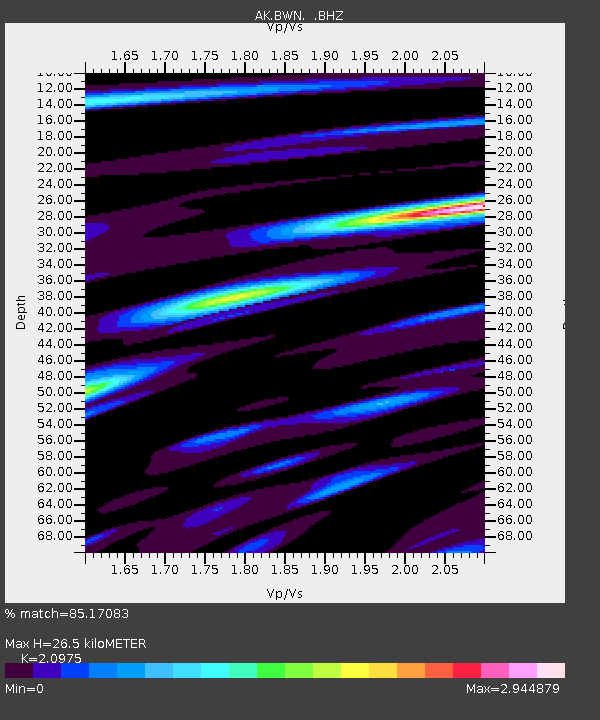
| Estimated Moho Depth: |
26.5 km |
| Estimated Crust Vp/Vs: |
2.10 |
| Assumed Crust Vp: |
6.566 km/s |
| Estimated Crust Vs: |
3.13 km/s |
| Estimated Crust Poisson's Ratio: |
0.35 |
|
| Radial Match: |
85.17083 % |
| Radial Bump: |
400 |
| Transverse Match: |
85.22122 % |
| Transverse Bump: |
400 |
| SOD ConfigId: |
512894 |
| Insert Time: |
2013-09-14 18:55:04.129 +0000 |
| GWidth: |
2.5 |
| Max Bumps: |
400 |
| Tol: |
0.001 |
|

Signal To Noise
| Channel | StoN | STA | LTA |
| AK:BWN: :BHZ:20130524T15:01:39.86799Z | 74.328766 | 2.3552617E-5 | 3.168708E-7 |
| AK:BWN: :BHN:20130524T15:01:39.86799Z | 71.4458 | 7.537922E-6 | 1.05505464E-7 |
| AK:BWN: :BHE:20130524T15:01:39.86799Z | 23.57294 | 7.712726E-6 | 3.2718557E-7 |
| Arrivals |
| Ps | 4.7 SECOND |
| PpPs | 12 SECOND |
| PsPs/PpSs | 16 SECOND |


