You are here: Home > Network List > AK - Alaska Regional Network Stations List
> Station WAT2 Susitna Watana 2, AK, USA > Earthquake Result Viewer
WAT2 Susitna Watana 2, AK, USA - Earthquake Result Viewer
| Earthquake location: |
Sea Of Okhotsk |
| Earthquake latitude/longitude: |
52.2/151.4 |
| Earthquake time(UTC): |
2013/05/24 (144) 14:56:31 GMT |
| Earthquake Depth: |
624 km |
| Earthquake Magnitude: |
6.7 MW, 6.7 MB, 6.7 MW |
| Earthquake Catalog/Contributor: |
NEIC PDE/NEIC PDE-W |
|
| Network: |
AK Alaska Regional Network |
| Station: |
WAT2 Susitna Watana 2, AK, USA |
| Lat/Lon: |
62.96 N/148.59 W |
| Elevation: |
1366 m |
|
| Distance: |
32.6 deg |
| Az: |
47.176 deg |
| Baz: |
279.238 deg |
| Ray Param: |
0.07544197 |
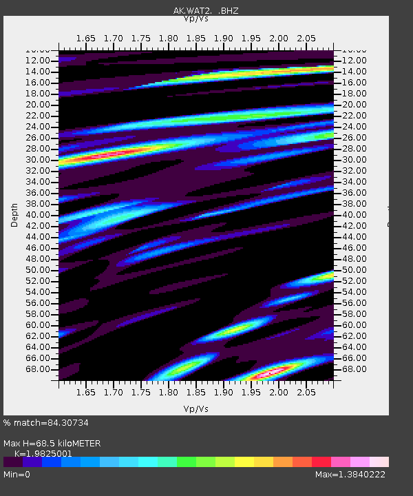
| Estimated Moho Depth: |
68.5 km |
| Estimated Crust Vp/Vs: |
1.98 |
| Assumed Crust Vp: |
6.566 km/s |
| Estimated Crust Vs: |
3.312 km/s |
| Estimated Crust Poisson's Ratio: |
0.33 |
|
| Radial Match: |
84.30734 % |
| Radial Bump: |
400 |
| Transverse Match: |
73.19229 % |
| Transverse Bump: |
400 |
| SOD ConfigId: |
512894 |
| Insert Time: |
2013-09-14 18:57:14.425 +0000 |
| GWidth: |
2.5 |
| Max Bumps: |
400 |
| Tol: |
0.001 |
|

Signal To Noise
| Channel | StoN | STA | LTA |
| AK:WAT2: :BHZ:20130524T15:01:43.948007Z | 57.8532 | 5.7025677E-6 | 9.8569615E-8 |
| AK:WAT2: :BHN:20130524T15:01:43.948007Z | 11.754373 | 2.3420314E-6 | 1.9924767E-7 |
| AK:WAT2: :BHE:20130524T15:01:43.948007Z | 25.814203 | 2.5236495E-6 | 9.7762054E-8 |
| Arrivals |
| Ps | 11 SECOND |
| PpPs | 29 SECOND |
| PsPs/PpSs | 40 SECOND |


