You are here: Home > Network List > AU - Australian Seismological Centre Stations List
> Station XMI Christmas Island Airport > Earthquake Result Viewer
XMI Christmas Island Airport - Earthquake Result Viewer
| Earthquake location: |
Sea Of Okhotsk |
| Earthquake latitude/longitude: |
52.2/151.4 |
| Earthquake time(UTC): |
2013/05/24 (144) 14:56:31 GMT |
| Earthquake Depth: |
624 km |
| Earthquake Magnitude: |
6.7 MW, 6.7 MB, 6.7 MW |
| Earthquake Catalog/Contributor: |
NEIC PDE/NEIC PDE-W |
|
| Network: |
AU Australian Seismological Centre |
| Station: |
XMI Christmas Island Airport |
| Lat/Lon: |
10.45 S/105.69 E |
| Elevation: |
252 m |
|
| Distance: |
73.7 deg |
| Az: |
227.222 deg |
| Baz: |
27.317 deg |
| Ray Param: |
0.050699 |
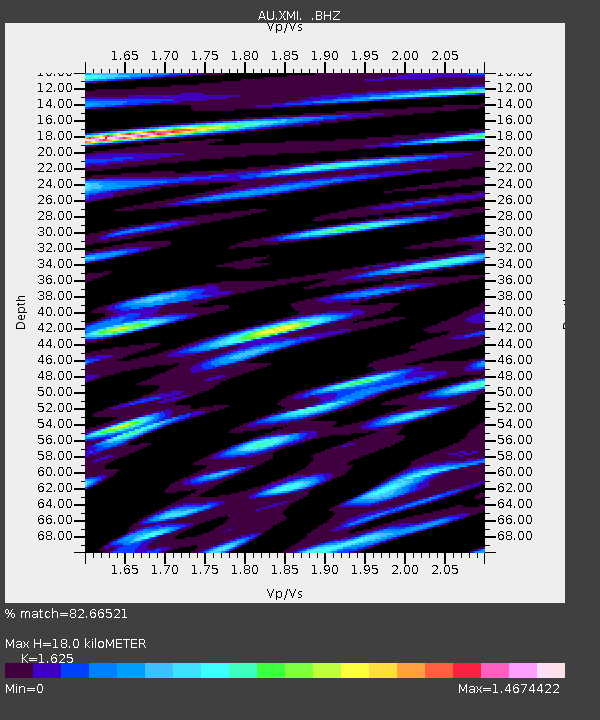
| Estimated Moho Depth: |
18.0 km |
| Estimated Crust Vp/Vs: |
1.62 |
| Assumed Crust Vp: |
4.157 km/s |
| Estimated Crust Vs: |
2.558 km/s |
| Estimated Crust Poisson's Ratio: |
0.20 |
|
| Radial Match: |
82.66521 % |
| Radial Bump: |
400 |
| Transverse Match: |
74.950005 % |
| Transverse Bump: |
400 |
| SOD ConfigId: |
512894 |
| Insert Time: |
2013-09-14 18:59:13.615 +0000 |
| GWidth: |
2.5 |
| Max Bumps: |
400 |
| Tol: |
0.001 |
|

Signal To Noise
| Channel | StoN | STA | LTA |
| AU:XMI: :BHZ:20130524T15:06:32.618997Z | 26.778467 | 2.4409175E-5 | 9.1152253E-7 |
| AU:XMI: :BHN:20130524T15:06:32.618997Z | 4.1855536 | 6.631511E-6 | 1.5843808E-6 |
| AU:XMI: :BHE:20130524T15:06:32.618997Z | 8.997934 | 8.1356775E-6 | 9.0417177E-7 |
| Arrivals |
| Ps | 2.7 SECOND |
| PpPs | 11 SECOND |
| PsPs/PpSs | 14 SECOND |


