You are here: Home > Network List > PS - Pacific21 Stations List
> Station TSK Tsukuba, Japan > Earthquake Result Viewer
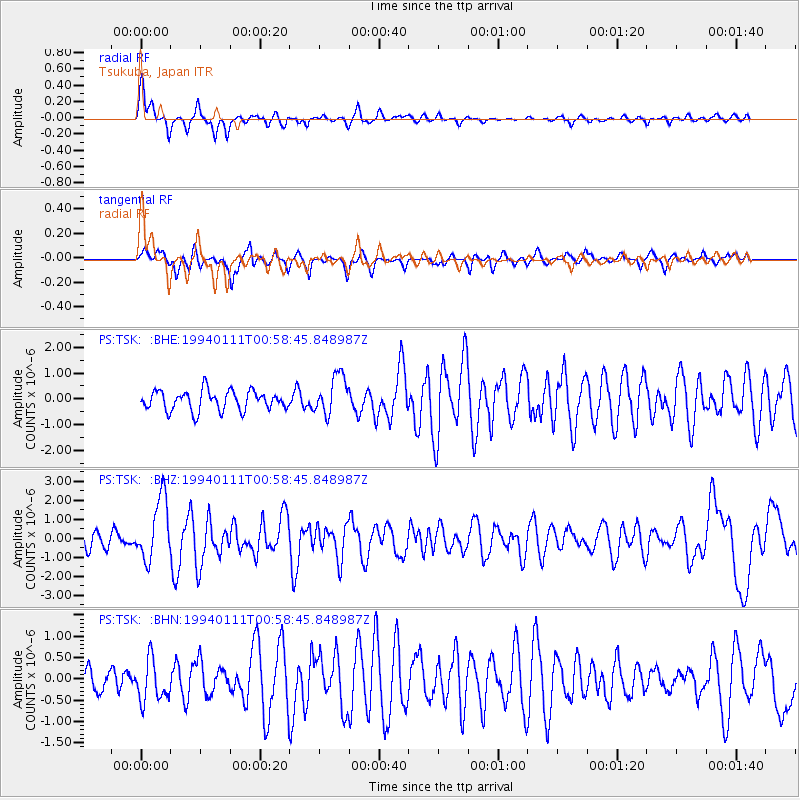
TSK Tsukuba, Japan - Earthquake Result Viewer
*The percent match for this event was below the threshold and hence no stack was calculated.
| Earthquake location: |
Myanmar-China Border Region |
| Earthquake latitude/longitude: |
25.2/97.2 |
| Earthquake time(UTC): |
1994/01/11 (011) 00:51:59 GMT |
| Earthquake Depth: |
33 km |
| Earthquake Magnitude: |
5.9 MB, 5.9 MS, 5.6 UNKNOWN, 6.1 MW |
| Earthquake Catalog/Contributor: |
WHDF/NEIC |
|
| Network: |
PS Pacific21 |
| Station: |
TSK Tsukuba, Japan |
| Lat/Lon: |
36.21 N/140.11 E |
| Elevation: |
350 m |
|
| Distance: |
38.2 deg |
| Az: |
62.883 deg |
| Baz: |
265.56 deg |
| Ray Param: |
$rayparam |
*The percent match for this event was below the threshold and hence was not used in the summary stack. |
|
| Radial Match: |
67.87618 % |
| Radial Bump: |
362 |
| Transverse Match: |
49.656013 % |
| Transverse Bump: |
400 |
| SOD ConfigId: |
4480 |
| Insert Time: |
2010-02-27 04:03:51.987 +0000 |
| GWidth: |
2.5 |
| Max Bumps: |
400 |
| Tol: |
0.001 |
|
Signal To Noise
| Channel | StoN | STA | LTA |
| PS:TSK: :BHZ:19940111T00:58:45.848987Z | 3.5224464 | 1.65033E-6 | 4.6851812E-7 |
| PS:TSK: :BHN:19940111T00:58:45.848987Z | 1.4168351 | 4.977552E-7 | 3.5131487E-7 |
| PS:TSK: :BHE:19940111T00:58:45.848987Z | 2.0053682 | 7.6677736E-7 | 3.823624E-7 |
| Arrivals |
| Ps | |
| PpPs | |
| PsPs/PpSs | |


