You are here: Home > Network List > XD14 - Illuminating the architecture of the greater Mount St. Helens magmatic systems f Stations List
> Station MP08 "Mount St Helens, WA" > Earthquake Result Viewer
MP08 "Mount St Helens, WA" - Earthquake Result Viewer
| Earthquake location: |
Andreanof Islands, Aleutian Is. |
| Earthquake latitude/longitude: |
51.2/-172.8 |
| Earthquake time(UTC): |
2014/08/10 (222) 18:27:38 GMT |
| Earthquake Depth: |
22 km |
| Earthquake Magnitude: |
5.0 MW, 4.4 ML, 5.0 mb |
| Earthquake Catalog/Contributor: |
ISC/ISC |
|
| Network: |
XD Illuminating the architecture of the greater Mount St. Helens magmatic systems f |
| Station: |
MP08 "Mount St Helens, WA" |
| Lat/Lon: |
45.87 N/121.91 W |
| Elevation: |
781 m |
|
| Distance: |
33.5 deg |
| Az: |
78.803 deg |
| Baz: |
297.939 deg |
| Ray Param: |
0.07814134 |
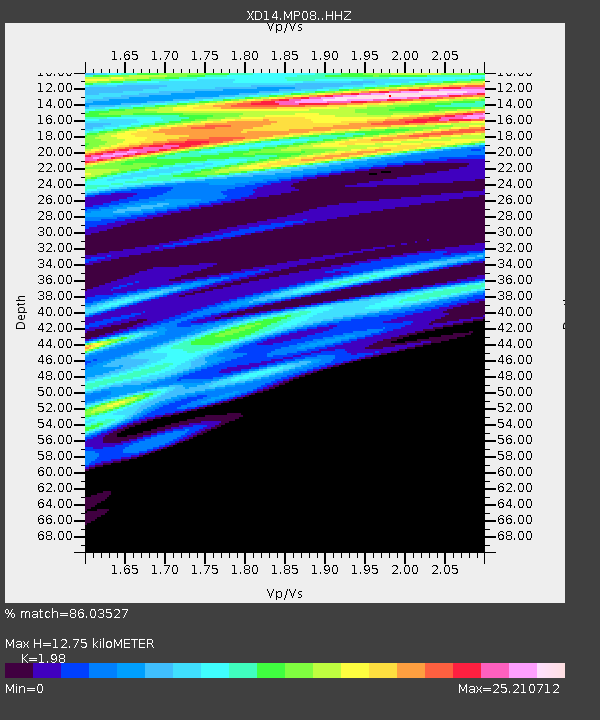
| Estimated Moho Depth: |
12.75 km |
| Estimated Crust Vp/Vs: |
1.98 |
| Assumed Crust Vp: |
6.597 km/s |
| Estimated Crust Vs: |
3.332 km/s |
| Estimated Crust Poisson's Ratio: |
0.33 |
|
| Radial Match: |
86.03527 % |
| Radial Bump: |
400 |
| Transverse Match: |
84.72974 % |
| Transverse Bump: |
400 |
| SOD ConfigId: |
3390531 |
| Insert Time: |
2019-04-13 07:17:44.762 +0000 |
| GWidth: |
2.5 |
| Max Bumps: |
400 |
| Tol: |
0.001 |
|

Signal To Noise
| Channel | StoN | STA | LTA |
| XD:MP08: :HHZ:20140810T18:33:45.890007Z | 0.6728767 | 8.8513666E-8 | 1.3154515E-7 |
| XD:MP08: :HHN:20140810T18:33:45.890007Z | 0.14516297 | 1.7147893E-7 | 1.1812857E-6 |
| XD:MP08: :HHE:20140810T18:33:45.890007Z | 0.25653487 | 2.1599112E-6 | 8.419562E-6 |
| Arrivals |
| Ps | 2.0 SECOND |
| PpPs | 5.4 SECOND |
| PsPs/PpSs | 7.4 SECOND |


