You are here: Home > Network List > IU - Global Seismograph Network (GSN - IRIS/USGS) Stations List
> Station CCM Cathedral Cave, Missouri, USA > Earthquake Result Viewer
CCM Cathedral Cave, Missouri, USA - Earthquake Result Viewer
| Earthquake location: |
Sea Of Okhotsk |
| Earthquake latitude/longitude: |
52.2/151.4 |
| Earthquake time(UTC): |
2013/05/24 (144) 14:56:31 GMT |
| Earthquake Depth: |
624 km |
| Earthquake Magnitude: |
6.7 MW, 6.7 MB, 6.7 MW |
| Earthquake Catalog/Contributor: |
NEIC PDE/NEIC PDE-W |
|
| Network: |
IU Global Seismograph Network (GSN - IRIS/USGS) |
| Station: |
CCM Cathedral Cave, Missouri, USA |
| Lat/Lon: |
38.06 N/91.24 W |
| Elevation: |
222 m |
|
| Distance: |
74.9 deg |
| Az: |
46.607 deg |
| Baz: |
325.521 deg |
| Ray Param: |
0.049986277 |
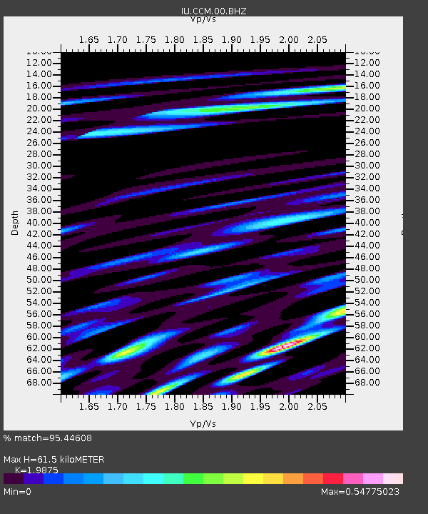
| Estimated Moho Depth: |
61.5 km |
| Estimated Crust Vp/Vs: |
1.99 |
| Assumed Crust Vp: |
6.498 km/s |
| Estimated Crust Vs: |
3.269 km/s |
| Estimated Crust Poisson's Ratio: |
0.33 |
|
| Radial Match: |
95.44608 % |
| Radial Bump: |
400 |
| Transverse Match: |
79.39903 % |
| Transverse Bump: |
400 |
| SOD ConfigId: |
512894 |
| Insert Time: |
2013-09-14 19:10:49.366 +0000 |
| GWidth: |
2.5 |
| Max Bumps: |
400 |
| Tol: |
0.001 |
|

Signal To Noise
| Channel | StoN | STA | LTA |
| IU:CCM:00:BHZ:20130524T15:06:38.868997Z | 42.739086 | 8.40272E-6 | 1.9660504E-7 |
| IU:CCM:00:BH1:20130524T15:06:38.868997Z | 29.016136 | 2.7815488E-6 | 9.5862134E-8 |
| IU:CCM:00:BH2:20130524T15:06:38.868997Z | 31.327854 | 2.4488743E-6 | 7.816923E-8 |
| Arrivals |
| Ps | 9.6 SECOND |
| PpPs | 28 SECOND |
| PsPs/PpSs | 37 SECOND |


