You are here: Home > Network List > IU - Global Seismograph Network (GSN - IRIS/USGS) Stations List
> Station RSSD Black Hills, South Dakota, USA > Earthquake Result Viewer
RSSD Black Hills, South Dakota, USA - Earthquake Result Viewer
| Earthquake location: |
Sea Of Okhotsk |
| Earthquake latitude/longitude: |
52.2/151.4 |
| Earthquake time(UTC): |
2013/05/24 (144) 14:56:31 GMT |
| Earthquake Depth: |
624 km |
| Earthquake Magnitude: |
6.7 MW, 6.7 MB, 6.7 MW |
| Earthquake Catalog/Contributor: |
NEIC PDE/NEIC PDE-W |
|
| Network: |
IU Global Seismograph Network (GSN - IRIS/USGS) |
| Station: |
RSSD Black Hills, South Dakota, USA |
| Lat/Lon: |
44.12 N/104.04 W |
| Elevation: |
2090 m |
|
| Distance: |
64.2 deg |
| Az: |
50.779 deg |
| Baz: |
318.582 deg |
| Ray Param: |
0.056716323 |
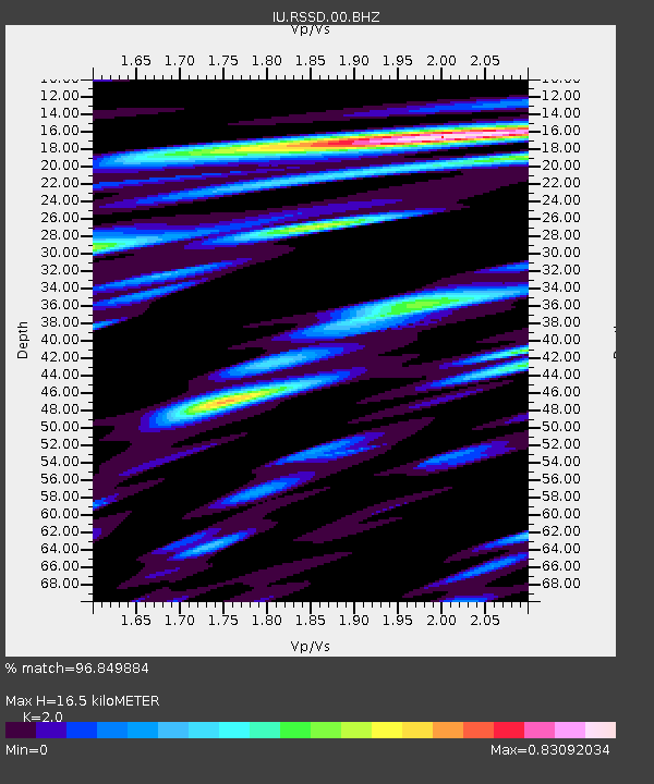
| Estimated Moho Depth: |
16.5 km |
| Estimated Crust Vp/Vs: |
2.00 |
| Assumed Crust Vp: |
6.242 km/s |
| Estimated Crust Vs: |
3.121 km/s |
| Estimated Crust Poisson's Ratio: |
0.33 |
|
| Radial Match: |
96.849884 % |
| Radial Bump: |
400 |
| Transverse Match: |
94.762985 % |
| Transverse Bump: |
400 |
| SOD ConfigId: |
512894 |
| Insert Time: |
2013-09-14 19:11:50.069 +0000 |
| GWidth: |
2.5 |
| Max Bumps: |
400 |
| Tol: |
0.001 |
|
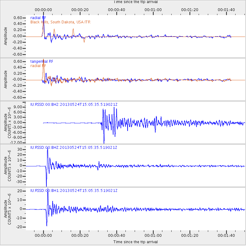
Signal To Noise
| Channel | StoN | STA | LTA |
| IU:RSSD:00:BHZ:20130524T15:05:35.519021Z | 43.07908 | 1.18388325E-5 | 2.748163E-7 |
| IU:RSSD:00:BH1:20130524T15:05:35.519021Z | 79.04423 | 6.8248546E-6 | 8.6342226E-8 |
| IU:RSSD:00:BH2:20130524T15:05:35.519021Z | 44.436302 | 4.061989E-6 | 9.141149E-8 |
| Arrivals |
| Ps | 2.7 SECOND |
| PpPs | 7.7 SECOND |
| PsPs/PpSs | 10 SECOND |


