You are here: Home > Network List > KN - Kyrgyz Seismic Telemetry Network Stations List
> Station TKM2 - > Earthquake Result Viewer
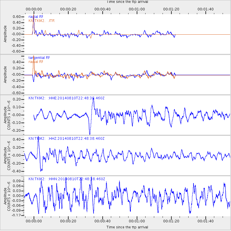
TKM2 - - Earthquake Result Viewer
*The percent match for this event was below the threshold and hence no stack was calculated.
| Earthquake location: |
Bonin Islands, Japan Region |
| Earthquake latitude/longitude: |
27.8/142.8 |
| Earthquake time(UTC): |
2014/08/10 (222) 22:39:37 GMT |
| Earthquake Depth: |
31 km |
| Earthquake Magnitude: |
5.1 MW, 5.1 mb |
| Earthquake Catalog/Contributor: |
ISC/ISC |
|
| Network: |
KN Kyrgyz Seismic Telemetry Network |
| Station: |
TKM2 - |
| Lat/Lon: |
42.92 N/75.60 E |
| Elevation: |
2020 m |
|
| Distance: |
55.5 deg |
| Az: |
304.696 deg |
| Baz: |
82.439 deg |
| Ray Param: |
$rayparam |
*The percent match for this event was below the threshold and hence was not used in the summary stack. |
|
| Radial Match: |
71.603645 % |
| Radial Bump: |
400 |
| Transverse Match: |
70.81488 % |
| Transverse Bump: |
400 |
| SOD ConfigId: |
3390531 |
| Insert Time: |
2019-04-13 07:28:07.258 +0000 |
| GWidth: |
2.5 |
| Max Bumps: |
400 |
| Tol: |
0.001 |
|
Signal To Noise
| Channel | StoN | STA | LTA |
| KN:TKM2: :HHZ:20140810T22:48:38.460Z | 4.4137845 | 2.1970968E-7 | 4.9778073E-8 |
| KN:TKM2: :HHN:20140810T22:48:38.460Z | 1.211899 | 4.9307815E-8 | 4.0686405E-8 |
| KN:TKM2: :HHE:20140810T22:48:38.460Z | 3.3549113 | 1.17195E-7 | 3.493237E-8 |
| Arrivals |
| Ps | |
| PpPs | |
| PsPs/PpSs | |


