You are here: Home > Network List > PE - Penn State Network Stations List
> Station PAGS PA Geological Survey > Earthquake Result Viewer
PAGS PA Geological Survey - Earthquake Result Viewer
| Earthquake location: |
Sea Of Okhotsk |
| Earthquake latitude/longitude: |
52.2/151.4 |
| Earthquake time(UTC): |
2013/05/24 (144) 14:56:31 GMT |
| Earthquake Depth: |
624 km |
| Earthquake Magnitude: |
6.7 MW, 6.7 MB, 6.7 MW |
| Earthquake Catalog/Contributor: |
NEIC PDE/NEIC PDE-W |
|
| Network: |
PE Penn State Network |
| Station: |
PAGS PA Geological Survey |
| Lat/Lon: |
40.23 N/76.72 W |
| Elevation: |
120 m |
|
| Distance: |
78.9 deg |
| Az: |
35.549 deg |
| Baz: |
332.159 deg |
| Ray Param: |
0.047378615 |
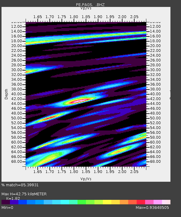
| Estimated Moho Depth: |
42.75 km |
| Estimated Crust Vp/Vs: |
1.82 |
| Assumed Crust Vp: |
6.121 km/s |
| Estimated Crust Vs: |
3.363 km/s |
| Estimated Crust Poisson's Ratio: |
0.28 |
|
| Radial Match: |
85.39931 % |
| Radial Bump: |
400 |
| Transverse Match: |
77.858765 % |
| Transverse Bump: |
400 |
| SOD ConfigId: |
512894 |
| Insert Time: |
2013-09-14 19:19:04.613 +0000 |
| GWidth: |
2.5 |
| Max Bumps: |
400 |
| Tol: |
0.001 |
|
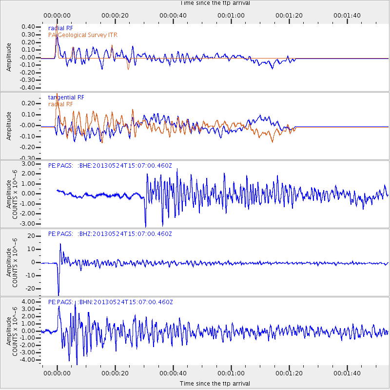
Signal To Noise
| Channel | StoN | STA | LTA |
| PE:PAGS: :BHZ:20130524T15:07:00.460Z | 40.81314 | 7.4764084E-6 | 1.831863E-7 |
| PE:PAGS: :BHN:20130524T15:07:00.460Z | 14.531963 | 1.736048E-6 | 1.194641E-7 |
| PE:PAGS: :BHE:20130524T15:07:00.460Z | 6.293844 | 1.1329776E-6 | 1.800136E-7 |
| Arrivals |
| Ps | 5.9 SECOND |
| PpPs | 19 SECOND |
| PsPs/PpSs | 25 SECOND |


