You are here: Home > Network List > PO - Portable Observatories for Lithospheric Analysis and Research Investigating Seis Stations List
> Station TYNO TYNESIDE, ON > Earthquake Result Viewer
TYNO TYNESIDE, ON - Earthquake Result Viewer
| Earthquake location: |
Sea Of Okhotsk |
| Earthquake latitude/longitude: |
52.2/151.4 |
| Earthquake time(UTC): |
2013/05/24 (144) 14:56:31 GMT |
| Earthquake Depth: |
624 km |
| Earthquake Magnitude: |
6.7 MW, 6.7 MB, 6.7 MW |
| Earthquake Catalog/Contributor: |
NEIC PDE/NEIC PDE-W |
|
| Network: |
PO Portable Observatories for Lithospheric Analysis and Research Investigating Seis |
| Station: |
TYNO TYNESIDE, ON |
| Lat/Lon: |
43.10 N/79.87 W |
| Elevation: |
205 m |
|
| Distance: |
75.2 deg |
| Az: |
36.254 deg |
| Baz: |
330.231 deg |
| Ray Param: |
0.049753763 |
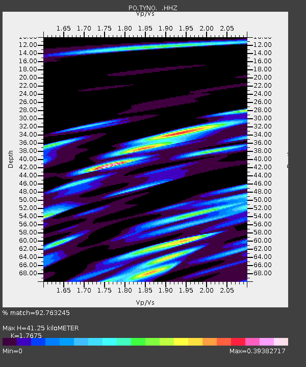
| Estimated Moho Depth: |
41.25 km |
| Estimated Crust Vp/Vs: |
1.77 |
| Assumed Crust Vp: |
6.419 km/s |
| Estimated Crust Vs: |
3.632 km/s |
| Estimated Crust Poisson's Ratio: |
0.26 |
|
| Radial Match: |
92.763245 % |
| Radial Bump: |
400 |
| Transverse Match: |
72.18493 % |
| Transverse Bump: |
400 |
| SOD ConfigId: |
512894 |
| Insert Time: |
2013-09-14 19:21:18.951 +0000 |
| GWidth: |
2.5 |
| Max Bumps: |
400 |
| Tol: |
0.001 |
|

Signal To Noise
| Channel | StoN | STA | LTA |
| PO:TYNO: :HHZ:20130524T15:06:40.809976Z | 50.041077 | 8.39532E-6 | 1.6776858E-7 |
| PO:TYNO: :HHN:20130524T15:06:40.809976Z | 16.258356 | 2.8856737E-6 | 1.7748866E-7 |
| PO:TYNO: :HHE:20130524T15:06:40.809976Z | 17.221981 | 1.8839468E-6 | 1.0939199E-7 |
| Arrivals |
| Ps | 5.1 SECOND |
| PpPs | 17 SECOND |
| PsPs/PpSs | 22 SECOND |


