You are here: Home > Network List > TA - USArray Transportable Network (new EarthScope stations) Stations List
> Station 150A Eclectic, AL, USA > Earthquake Result Viewer
150A Eclectic, AL, USA - Earthquake Result Viewer
| Earthquake location: |
Sea Of Okhotsk |
| Earthquake latitude/longitude: |
52.2/151.4 |
| Earthquake time(UTC): |
2013/05/24 (144) 14:56:31 GMT |
| Earthquake Depth: |
624 km |
| Earthquake Magnitude: |
6.7 MW, 6.7 MB, 6.7 MW |
| Earthquake Catalog/Contributor: |
NEIC PDE/NEIC PDE-W |
|
| Network: |
TA USArray Transportable Network (new EarthScope stations) |
| Station: |
150A Eclectic, AL, USA |
| Lat/Lon: |
32.61 N/86.02 W |
| Elevation: |
145 m |
|
| Distance: |
81.7 deg |
| Az: |
45.975 deg |
| Baz: |
328.404 deg |
| Ray Param: |
0.045462936 |
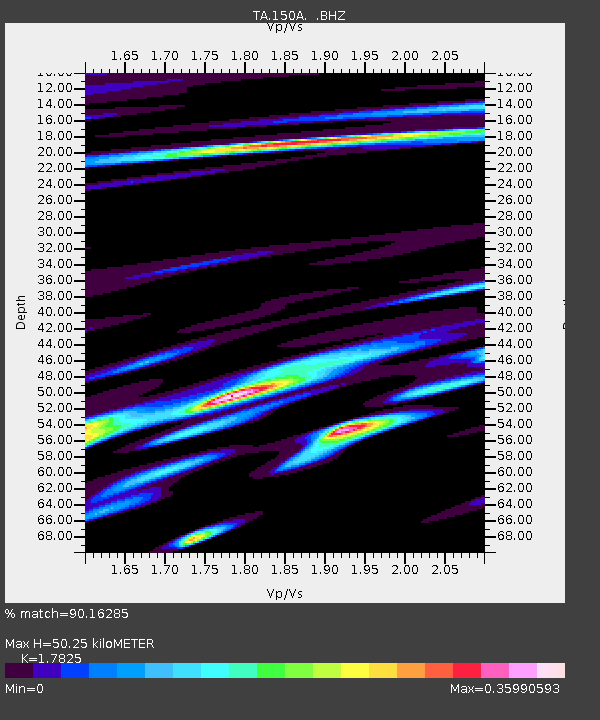
| Estimated Moho Depth: |
50.25 km |
| Estimated Crust Vp/Vs: |
1.78 |
| Assumed Crust Vp: |
6.565 km/s |
| Estimated Crust Vs: |
3.683 km/s |
| Estimated Crust Poisson's Ratio: |
0.27 |
|
| Radial Match: |
90.16285 % |
| Radial Bump: |
400 |
| Transverse Match: |
79.47245 % |
| Transverse Bump: |
400 |
| SOD ConfigId: |
512894 |
| Insert Time: |
2013-09-14 19:23:40.657 +0000 |
| GWidth: |
2.5 |
| Max Bumps: |
400 |
| Tol: |
0.001 |
|
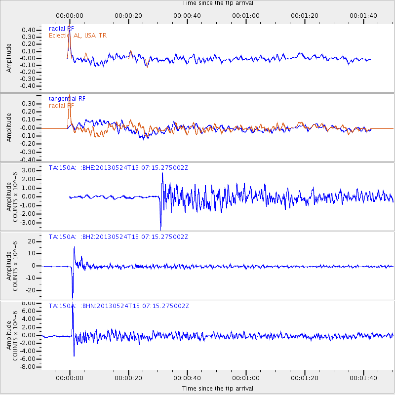
Signal To Noise
| Channel | StoN | STA | LTA |
| TA:150A: :BHZ:20130524T15:07:15.275002Z | 54.392414 | 7.3079987E-6 | 1.3435694E-7 |
| TA:150A: :BHN:20130524T15:07:15.275002Z | 15.543444 | 2.125666E-6 | 1.3675644E-7 |
| TA:150A: :BHE:20130524T15:07:15.275002Z | 12.342632 | 1.2514259E-6 | 1.01390526E-7 |
| Arrivals |
| Ps | 6.1 SECOND |
| PpPs | 21 SECOND |
| PsPs/PpSs | 27 SECOND |


