You are here: Home > Network List > TA - USArray Transportable Network (new EarthScope stations) Stations List
> Station 155A Kite, GA, USA > Earthquake Result Viewer
155A Kite, GA, USA - Earthquake Result Viewer
| Earthquake location: |
Sea Of Okhotsk |
| Earthquake latitude/longitude: |
52.2/151.4 |
| Earthquake time(UTC): |
2013/05/24 (144) 14:56:31 GMT |
| Earthquake Depth: |
624 km |
| Earthquake Magnitude: |
6.7 MW, 6.7 MB, 6.7 MW |
| Earthquake Catalog/Contributor: |
NEIC PDE/NEIC PDE-W |
|
| Network: |
TA USArray Transportable Network (new EarthScope stations) |
| Station: |
155A Kite, GA, USA |
| Lat/Lon: |
32.62 N/82.47 W |
| Elevation: |
93 m |
|
| Distance: |
83.3 deg |
| Az: |
43.368 deg |
| Baz: |
329.971 deg |
| Ray Param: |
0.044423852 |
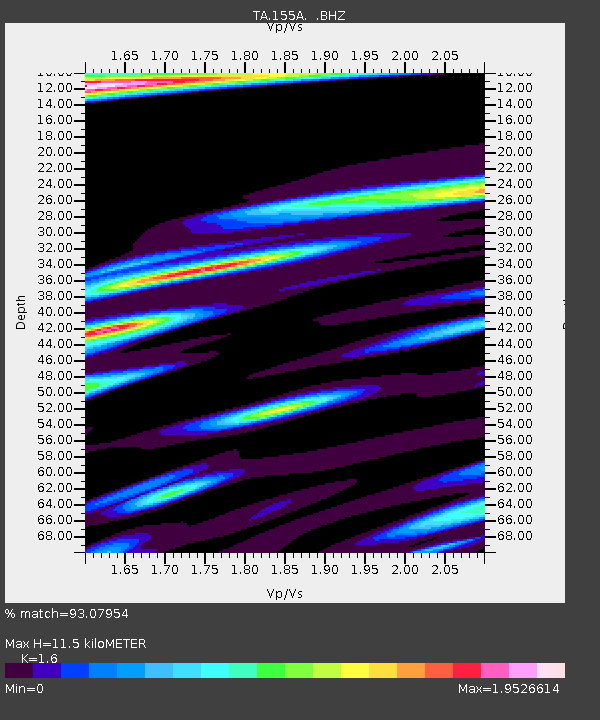
| Estimated Moho Depth: |
11.5 km |
| Estimated Crust Vp/Vs: |
1.60 |
| Assumed Crust Vp: |
6.565 km/s |
| Estimated Crust Vs: |
4.103 km/s |
| Estimated Crust Poisson's Ratio: |
0.18 |
|
| Radial Match: |
93.07954 % |
| Radial Bump: |
400 |
| Transverse Match: |
87.68343 % |
| Transverse Bump: |
400 |
| SOD ConfigId: |
512894 |
| Insert Time: |
2013-09-14 19:23:53.461 +0000 |
| GWidth: |
2.5 |
| Max Bumps: |
400 |
| Tol: |
0.001 |
|
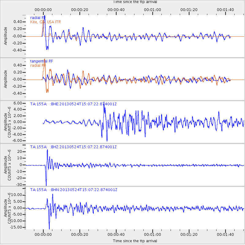
Signal To Noise
| Channel | StoN | STA | LTA |
| TA:155A: :BHZ:20130524T15:07:22.874001Z | 44.079285 | 1.0565906E-5 | 2.397023E-7 |
| TA:155A: :BHN:20130524T15:07:22.874001Z | 13.153026 | 4.6996674E-6 | 3.5730696E-7 |
| TA:155A: :BHE:20130524T15:07:22.874001Z | 6.367551 | 2.4152025E-6 | 3.792985E-7 |
| Arrivals |
| Ps | 1.1 SECOND |
| PpPs | 4.4 SECOND |
| PsPs/PpSs | 5.5 SECOND |


