You are here: Home > Network List > TA - USArray Transportable Network (new EarthScope stations) Stations List
> Station 251A Midway, AL, USA > Earthquake Result Viewer
251A Midway, AL, USA - Earthquake Result Viewer
| Earthquake location: |
Sea Of Okhotsk |
| Earthquake latitude/longitude: |
52.2/151.4 |
| Earthquake time(UTC): |
2013/05/24 (144) 14:56:31 GMT |
| Earthquake Depth: |
624 km |
| Earthquake Magnitude: |
6.7 MW, 6.7 MB, 6.7 MW |
| Earthquake Catalog/Contributor: |
NEIC PDE/NEIC PDE-W |
|
| Network: |
TA USArray Transportable Network (new EarthScope stations) |
| Station: |
251A Midway, AL, USA |
| Lat/Lon: |
32.09 N/85.41 W |
| Elevation: |
139 m |
|
| Distance: |
82.4 deg |
| Az: |
45.798 deg |
| Baz: |
328.706 deg |
| Ray Param: |
0.044979736 |
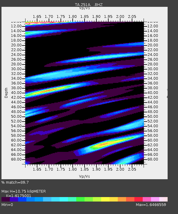
| Estimated Moho Depth: |
10.75 km |
| Estimated Crust Vp/Vs: |
1.62 |
| Assumed Crust Vp: |
6.719 km/s |
| Estimated Crust Vs: |
4.154 km/s |
| Estimated Crust Poisson's Ratio: |
0.19 |
|
| Radial Match: |
89.7 % |
| Radial Bump: |
400 |
| Transverse Match: |
78.42133 % |
| Transverse Bump: |
400 |
| SOD ConfigId: |
512894 |
| Insert Time: |
2013-09-14 19:24:09.908 +0000 |
| GWidth: |
2.5 |
| Max Bumps: |
400 |
| Tol: |
0.001 |
|
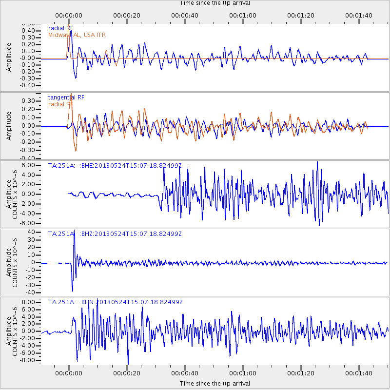
Signal To Noise
| Channel | StoN | STA | LTA |
| TA:251A: :BHZ:20130524T15:07:18.82499Z | 120.79768 | 1.4510819E-5 | 1.2012498E-7 |
| TA:251A: :BHN:20130524T15:07:18.82499Z | 14.788258 | 3.2462515E-6 | 2.1951548E-7 |
| TA:251A: :BHE:20130524T15:07:18.82499Z | 6.362215 | 1.926692E-6 | 3.028335E-7 |
| Arrivals |
| Ps | 1.0 SECOND |
| PpPs | 4.1 SECOND |
| PsPs/PpSs | 5.1 SECOND |


