You are here: Home > Network List > TA - USArray Transportable Network (new EarthScope stations) Stations List
> Station 256A Glennville, GA, USA > Earthquake Result Viewer
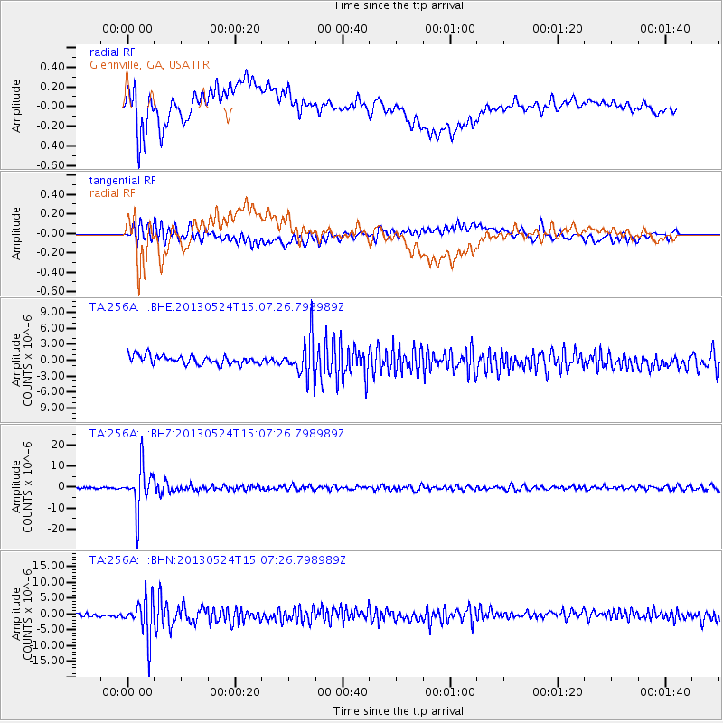
256A Glennville, GA, USA - Earthquake Result Viewer
*The percent match for this event was below the threshold and hence no stack was calculated.
| Earthquake location: |
Sea Of Okhotsk |
| Earthquake latitude/longitude: |
52.2/151.4 |
| Earthquake time(UTC): |
2013/05/24 (144) 14:56:31 GMT |
| Earthquake Depth: |
624 km |
| Earthquake Magnitude: |
6.7 MW, 6.7 MB, 6.7 MW |
| Earthquake Catalog/Contributor: |
NEIC PDE/NEIC PDE-W |
|
| Network: |
TA USArray Transportable Network (new EarthScope stations) |
| Station: |
256A Glennville, GA, USA |
| Lat/Lon: |
31.98 N/81.89 W |
| Elevation: |
46 m |
|
| Distance: |
84.1 deg |
| Az: |
43.262 deg |
| Baz: |
330.267 deg |
| Ray Param: |
$rayparam |
*The percent match for this event was below the threshold and hence was not used in the summary stack. |
|
| Radial Match: |
61.22402 % |
| Radial Bump: |
400 |
| Transverse Match: |
59.796616 % |
| Transverse Bump: |
400 |
| SOD ConfigId: |
512894 |
| Insert Time: |
2013-09-14 19:24:22.507 +0000 |
| GWidth: |
2.5 |
| Max Bumps: |
400 |
| Tol: |
0.001 |
|
Signal To Noise
| Channel | StoN | STA | LTA |
| TA:256A: :BHZ:20130524T15:07:26.798989Z | 29.846985 | 1.0178805E-5 | 3.4103292E-7 |
| TA:256A: :BHN:20130524T15:07:26.798989Z | 15.900188 | 6.127271E-6 | 3.8535836E-7 |
| TA:256A: :BHE:20130524T15:07:26.798989Z | 4.4300814 | 3.6012193E-6 | 8.129014E-7 |
| Arrivals |
| Ps | |
| PpPs | |
| PsPs/PpSs | |


