You are here: Home > Network List > TA - USArray Transportable Network (new EarthScope stations) Stations List
> Station 452A Marianna, FL, USA > Earthquake Result Viewer
452A Marianna, FL, USA - Earthquake Result Viewer
| Earthquake location: |
Sea Of Okhotsk |
| Earthquake latitude/longitude: |
52.2/151.4 |
| Earthquake time(UTC): |
2013/05/24 (144) 14:56:31 GMT |
| Earthquake Depth: |
624 km |
| Earthquake Magnitude: |
6.7 MW, 6.7 MB, 6.7 MW |
| Earthquake Catalog/Contributor: |
NEIC PDE/NEIC PDE-W |
|
| Network: |
TA USArray Transportable Network (new EarthScope stations) |
| Station: |
452A Marianna, FL, USA |
| Lat/Lon: |
30.85 N/85.18 W |
| Elevation: |
35 m |
|
| Distance: |
83.6 deg |
| Az: |
46.279 deg |
| Baz: |
328.882 deg |
| Ray Param: |
0.044191737 |
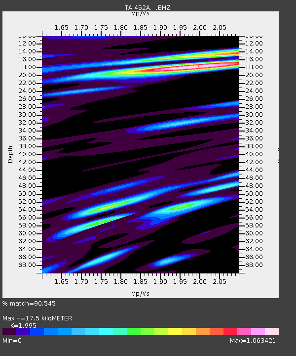
| Estimated Moho Depth: |
17.5 km |
| Estimated Crust Vp/Vs: |
2.00 |
| Assumed Crust Vp: |
6.347 km/s |
| Estimated Crust Vs: |
3.181 km/s |
| Estimated Crust Poisson's Ratio: |
0.33 |
|
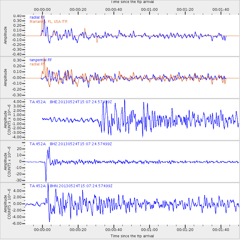
| Radial Match: |
90.545 % |
| Radial Bump: |
400 |
| Transverse Match: |
88.40269 % |
| Transverse Bump: |
400 |
| SOD ConfigId: |
512894 |
| Insert Time: |
2013-09-14 19:24:59.204 +0000 |
| GWidth: |
2.5 |
| Max Bumps: |
400 |
| Tol: |
0.001 |
|
Signal To Noise
| Channel | StoN | STA | LTA |
| TA:452A: :BHZ:20130524T15:07:24.57499Z | 36.31461 | 1.1550324E-5 | 3.1806275E-7 |
| TA:452A: :BHN:20130524T15:07:24.57499Z | 11.239342 | 2.2565878E-6 | 2.007758E-7 |
| TA:452A: :BHE:20130524T15:07:24.57499Z | 5.8887267 | 1.5737066E-6 | 2.6724055E-7 |
| Arrivals |
| Ps | 2.8 SECOND |
| PpPs | 8.1 SECOND |
| PsPs/PpSs | 11 SECOND |


