You are here: Home > Network List > TA - USArray Transportable Network (new EarthScope stations) Stations List
> Station 454A Quitman, GA, USA > Earthquake Result Viewer
454A Quitman, GA, USA - Earthquake Result Viewer
| Earthquake location: |
Sea Of Okhotsk |
| Earthquake latitude/longitude: |
52.2/151.4 |
| Earthquake time(UTC): |
2013/05/24 (144) 14:56:31 GMT |
| Earthquake Depth: |
624 km |
| Earthquake Magnitude: |
6.7 MW, 6.7 MB, 6.7 MW |
| Earthquake Catalog/Contributor: |
NEIC PDE/NEIC PDE-W |
|
| Network: |
TA USArray Transportable Network (new EarthScope stations) |
| Station: |
454A Quitman, GA, USA |
| Lat/Lon: |
30.71 N/83.63 W |
| Elevation: |
50 m |
|
| Distance: |
84.4 deg |
| Az: |
45.194 deg |
| Baz: |
329.559 deg |
| Ray Param: |
0.04364097 |
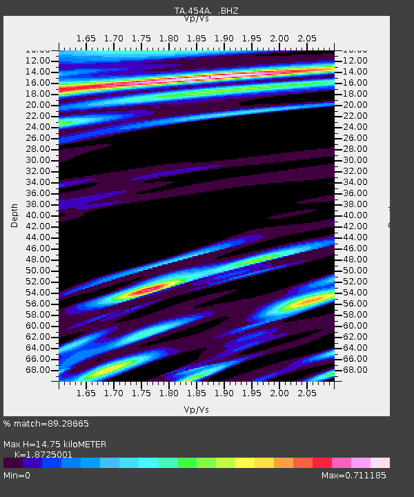
| Estimated Moho Depth: |
14.75 km |
| Estimated Crust Vp/Vs: |
1.87 |
| Assumed Crust Vp: |
6.565 km/s |
| Estimated Crust Vs: |
3.506 km/s |
| Estimated Crust Poisson's Ratio: |
0.30 |
|
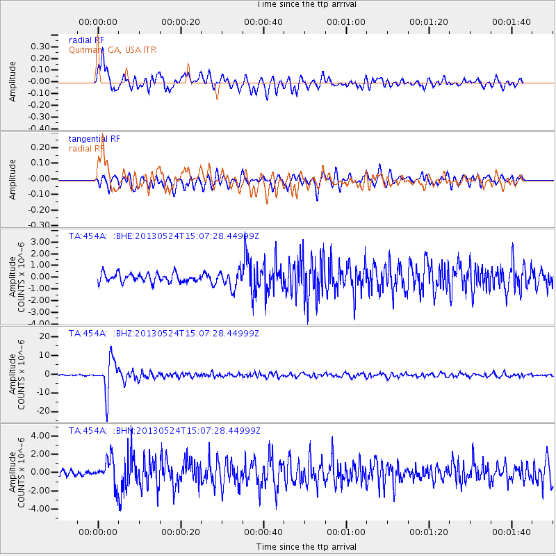
| Radial Match: |
89.28665 % |
| Radial Bump: |
400 |
| Transverse Match: |
78.23254 % |
| Transverse Bump: |
400 |
| SOD ConfigId: |
512894 |
| Insert Time: |
2013-09-14 19:25:05.717 +0000 |
| GWidth: |
2.5 |
| Max Bumps: |
400 |
| Tol: |
0.001 |
|
Signal To Noise
| Channel | StoN | STA | LTA |
| TA:454A: :BHZ:20130524T15:07:28.44999Z | 25.038769 | 9.1747115E-6 | 3.664202E-7 |
| TA:454A: :BHN:20130524T15:07:28.44999Z | 5.1644897 | 1.4715162E-6 | 2.8492963E-7 |
| TA:454A: :BHE:20130524T15:07:28.44999Z | 2.071537 | 7.3746725E-7 | 3.5600002E-7 |
| Arrivals |
| Ps | 2.0 SECOND |
| PpPs | 6.3 SECOND |
| PsPs/PpSs | 8.3 SECOND |


