You are here: Home > Network List > TA - USArray Transportable Network (new EarthScope stations) Stations List
> Station 455A Stateville, GA, USA > Earthquake Result Viewer
455A Stateville, GA, USA - Earthquake Result Viewer
| Earthquake location: |
Sea Of Okhotsk |
| Earthquake latitude/longitude: |
52.2/151.4 |
| Earthquake time(UTC): |
2013/05/24 (144) 14:56:31 GMT |
| Earthquake Depth: |
624 km |
| Earthquake Magnitude: |
6.7 MW, 6.7 MB, 6.7 MW |
| Earthquake Catalog/Contributor: |
NEIC PDE/NEIC PDE-W |
|
| Network: |
TA USArray Transportable Network (new EarthScope stations) |
| Station: |
455A Stateville, GA, USA |
| Lat/Lon: |
30.74 N/83.03 W |
| Elevation: |
44 m |
|
| Distance: |
84.6 deg |
| Az: |
44.729 deg |
| Baz: |
329.822 deg |
| Ray Param: |
0.043474793 |
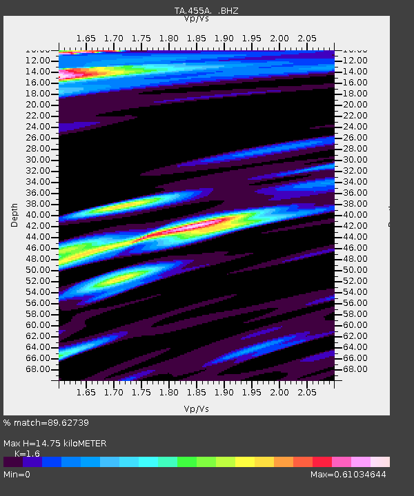
| Estimated Moho Depth: |
14.75 km |
| Estimated Crust Vp/Vs: |
1.60 |
| Assumed Crust Vp: |
6.565 km/s |
| Estimated Crust Vs: |
4.103 km/s |
| Estimated Crust Poisson's Ratio: |
0.18 |
|
| Radial Match: |
89.62739 % |
| Radial Bump: |
400 |
| Transverse Match: |
77.693474 % |
| Transverse Bump: |
400 |
| SOD ConfigId: |
512894 |
| Insert Time: |
2013-09-14 19:25:06.000 +0000 |
| GWidth: |
2.5 |
| Max Bumps: |
400 |
| Tol: |
0.001 |
|

Signal To Noise
| Channel | StoN | STA | LTA |
| TA:455A: :BHZ:20130524T15:07:29.624978Z | 28.872803 | 9.755536E-6 | 3.3787978E-7 |
| TA:455A: :BHN:20130524T15:07:29.624978Z | 8.75254 | 2.2795361E-6 | 2.6044285E-7 |
| TA:455A: :BHE:20130524T15:07:29.624978Z | 6.916376 | 1.634226E-6 | 2.3628357E-7 |
| Arrivals |
| Ps | 1.4 SECOND |
| PpPs | 5.7 SECOND |
| PsPs/PpSs | 7.1 SECOND |


