You are here: Home > Network List > TA - USArray Transportable Network (new EarthScope stations) Stations List
> Station 456A Hilliard, FL, USA > Earthquake Result Viewer
456A Hilliard, FL, USA - Earthquake Result Viewer
| Earthquake location: |
Sea Of Okhotsk |
| Earthquake latitude/longitude: |
52.2/151.4 |
| Earthquake time(UTC): |
2013/05/24 (144) 14:56:31 GMT |
| Earthquake Depth: |
624 km |
| Earthquake Magnitude: |
6.7 MW, 6.7 MB, 6.7 MW |
| Earthquake Catalog/Contributor: |
NEIC PDE/NEIC PDE-W |
|
| Network: |
TA USArray Transportable Network (new EarthScope stations) |
| Station: |
456A Hilliard, FL, USA |
| Lat/Lon: |
30.72 N/82.02 W |
| Elevation: |
26 m |
|
| Distance: |
85.1 deg |
| Az: |
43.985 deg |
| Baz: |
330.266 deg |
| Ray Param: |
0.043170933 |
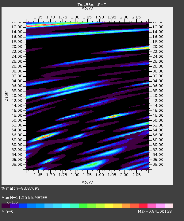
| Estimated Moho Depth: |
11.25 km |
| Estimated Crust Vp/Vs: |
1.60 |
| Assumed Crust Vp: |
6.565 km/s |
| Estimated Crust Vs: |
4.103 km/s |
| Estimated Crust Poisson's Ratio: |
0.18 |
|
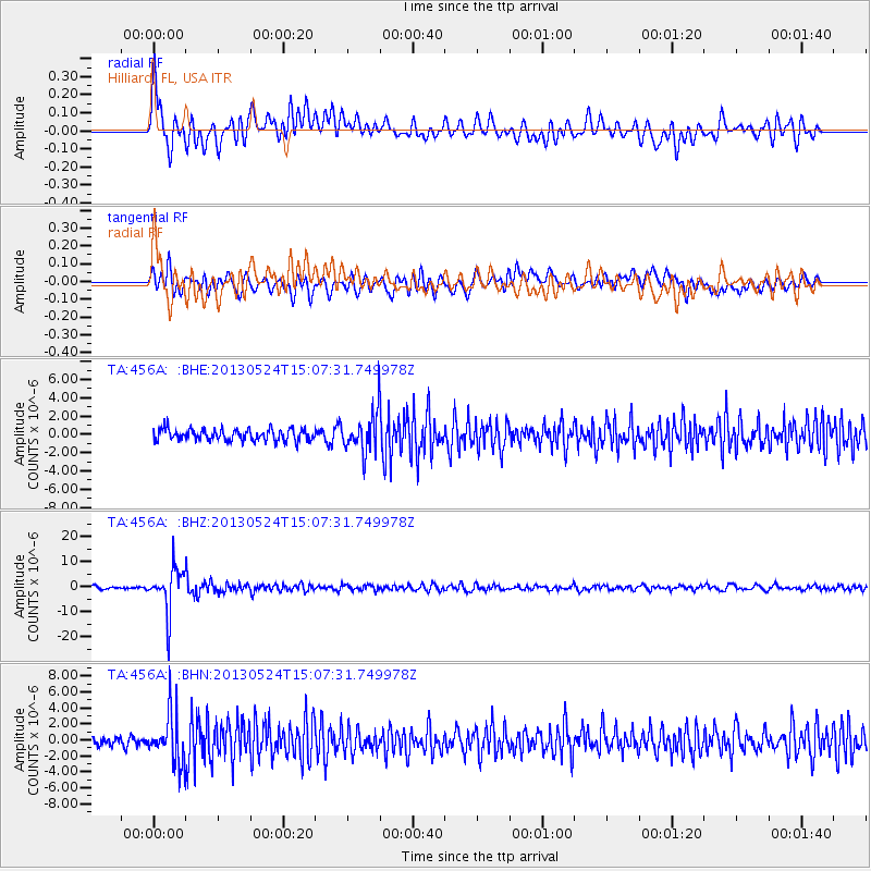
| Radial Match: |
83.87693 % |
| Radial Bump: |
400 |
| Transverse Match: |
69.27893 % |
| Transverse Bump: |
400 |
| SOD ConfigId: |
512894 |
| Insert Time: |
2013-09-14 19:25:10.653 +0000 |
| GWidth: |
2.5 |
| Max Bumps: |
400 |
| Tol: |
0.001 |
|
Signal To Noise
| Channel | StoN | STA | LTA |
| TA:456A: :BHZ:20130524T15:07:31.749978Z | 16.952768 | 8.994862E-6 | 5.3058363E-7 |
| TA:456A: :BHN:20130524T15:07:31.749978Z | 5.7599125 | 2.9744317E-6 | 5.164023E-7 |
| TA:456A: :BHE:20130524T15:07:31.749978Z | 3.5083187 | 2.1933045E-6 | 6.251725E-7 |
| Arrivals |
| Ps | 1.1 SECOND |
| PpPs | 4.3 SECOND |
| PsPs/PpSs | 5.4 SECOND |


