You are here: Home > Network List > TA - USArray Transportable Network (new EarthScope stations) Stations List
> Station 555A McAlpin, FL, USA > Earthquake Result Viewer
555A McAlpin, FL, USA - Earthquake Result Viewer
| Earthquake location: |
Sea Of Okhotsk |
| Earthquake latitude/longitude: |
52.2/151.4 |
| Earthquake time(UTC): |
2013/05/24 (144) 14:56:31 GMT |
| Earthquake Depth: |
624 km |
| Earthquake Magnitude: |
6.7 MW, 6.7 MB, 6.7 MW |
| Earthquake Catalog/Contributor: |
NEIC PDE/NEIC PDE-W |
|
| Network: |
TA USArray Transportable Network (new EarthScope stations) |
| Station: |
555A McAlpin, FL, USA |
| Lat/Lon: |
30.12 N/82.97 W |
| Elevation: |
29 m |
|
| Distance: |
85.2 deg |
| Az: |
44.996 deg |
| Baz: |
329.876 deg |
| Ray Param: |
0.043090165 |
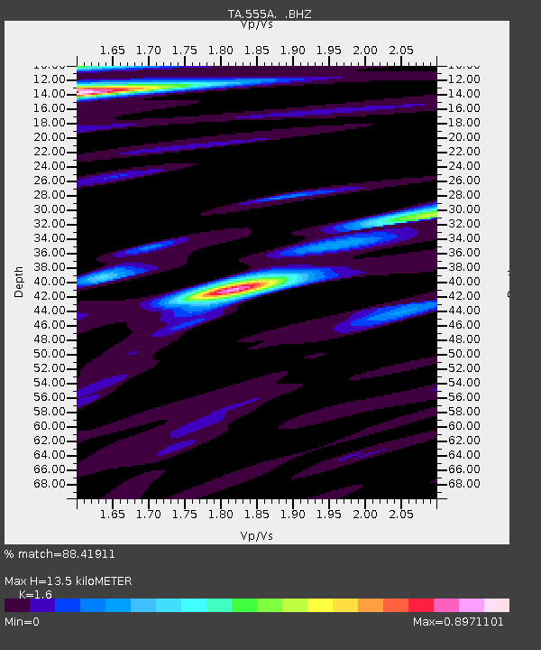
| Estimated Moho Depth: |
13.5 km |
| Estimated Crust Vp/Vs: |
1.60 |
| Assumed Crust Vp: |
6.565 km/s |
| Estimated Crust Vs: |
4.103 km/s |
| Estimated Crust Poisson's Ratio: |
0.18 |
|
| Radial Match: |
88.41911 % |
| Radial Bump: |
400 |
| Transverse Match: |
74.2891 % |
| Transverse Bump: |
400 |
| SOD ConfigId: |
512894 |
| Insert Time: |
2013-09-14 19:25:21.111 +0000 |
| GWidth: |
2.5 |
| Max Bumps: |
400 |
| Tol: |
0.001 |
|
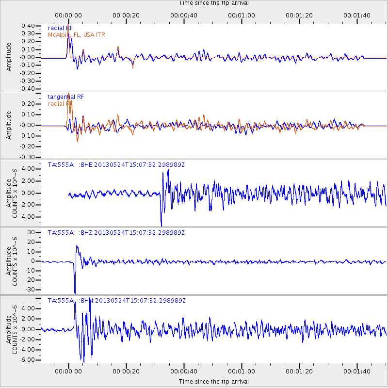
Signal To Noise
| Channel | StoN | STA | LTA |
| TA:555A: :BHZ:20130524T15:07:32.298989Z | 29.303331 | 1.070467E-5 | 3.6530557E-7 |
| TA:555A: :BHN:20130524T15:07:32.298989Z | 9.111767 | 2.2793265E-6 | 2.5015197E-7 |
| TA:555A: :BHE:20130524T15:07:32.298989Z | 6.048591 | 1.9751617E-6 | 3.2654904E-7 |
| Arrivals |
| Ps | 1.3 SECOND |
| PpPs | 5.2 SECOND |
| PsPs/PpSs | 6.5 SECOND |


