You are here: Home > Network List > TA - USArray Transportable Network (new EarthScope stations) Stations List
> Station 554A Perry, FL, USA > Earthquake Result Viewer
554A Perry, FL, USA - Earthquake Result Viewer
| Earthquake location: |
Sea Of Okhotsk |
| Earthquake latitude/longitude: |
52.2/151.4 |
| Earthquake time(UTC): |
2013/05/24 (144) 14:56:31 GMT |
| Earthquake Depth: |
624 km |
| Earthquake Magnitude: |
6.7 MW, 6.7 MB, 6.7 MW |
| Earthquake Catalog/Contributor: |
NEIC PDE/NEIC PDE-W |
|
| Network: |
TA USArray Transportable Network (new EarthScope stations) |
| Station: |
554A Perry, FL, USA |
| Lat/Lon: |
30.08 N/83.68 W |
| Elevation: |
12 m |
|
| Distance: |
84.9 deg |
| Az: |
45.553 deg |
| Baz: |
329.566 deg |
| Ray Param: |
0.04328673 |
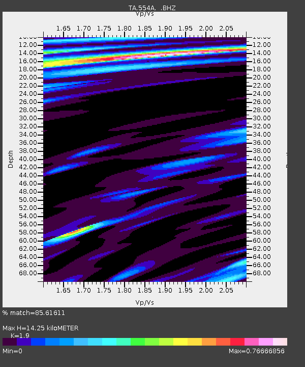
| Estimated Moho Depth: |
14.25 km |
| Estimated Crust Vp/Vs: |
1.90 |
| Assumed Crust Vp: |
6.565 km/s |
| Estimated Crust Vs: |
3.455 km/s |
| Estimated Crust Poisson's Ratio: |
0.31 |
|
| Radial Match: |
85.61611 % |
| Radial Bump: |
400 |
| Transverse Match: |
83.31508 % |
| Transverse Bump: |
400 |
| SOD ConfigId: |
512894 |
| Insert Time: |
2013-09-14 19:25:21.416 +0000 |
| GWidth: |
2.5 |
| Max Bumps: |
400 |
| Tol: |
0.001 |
|

Signal To Noise
| Channel | StoN | STA | LTA |
| TA:554A: :BHZ:20130524T15:07:30.94999Z | 36.940403 | 1.0982112E-5 | 2.972927E-7 |
| TA:554A: :BHN:20130524T15:07:30.94999Z | 7.1741657 | 1.6415004E-6 | 2.2880715E-7 |
| TA:554A: :BHE:20130524T15:07:30.94999Z | 5.306196 | 1.0122691E-6 | 1.9077113E-7 |
| Arrivals |
| Ps | 2.0 SECOND |
| PpPs | 6.2 SECOND |
| PsPs/PpSs | 8.2 SECOND |


