You are here: Home > Network List > TA - USArray Transportable Network (new EarthScope stations) Stations List
> Station 656A Willston, FL, USA > Earthquake Result Viewer
656A Willston, FL, USA - Earthquake Result Viewer

| Earthquake location: |
Sea Of Okhotsk |
| Earthquake latitude/longitude: |
52.2/151.4 |
| Earthquake time(UTC): |
2013/05/24 (144) 14:56:31 GMT |
| Earthquake Depth: |
624 km |
| Earthquake Magnitude: |
6.7 MW, 6.7 MB, 6.7 MW |
| Earthquake Catalog/Contributor: |
NEIC PDE/NEIC PDE-W |
|
| Network: |
TA USArray Transportable Network (new EarthScope stations) |
| Station: |
656A Willston, FL, USA |
| Lat/Lon: |
29.37 N/82.53 W |
| Elevation: |
28 m |
|
| Distance: |
86.0 deg |
| Az: |
45.046 deg |
| Baz: |
330.093 deg |
| Ray Param: |
0.042499285 |
| Estimated Moho Depth: |
33.25 km |
| Estimated Crust Vp/Vs: |
1.90 |
| Assumed Crust Vp: |
5.989 km/s |
| Estimated Crust Vs: |
3.156 km/s |
| Estimated Crust Poisson's Ratio: |
0.31 |
|
| Radial Match: |
95.55659 % |
| Radial Bump: |
400 |
| Transverse Match: |
83.470184 % |
| Transverse Bump: |
400 |
| SOD ConfigId: |
512894 |
| Insert Time: |
2013-09-14 19:25:31.545 +0000 |
| GWidth: |
2.5 |
| Max Bumps: |
400 |
| Tol: |
0.001 |
|
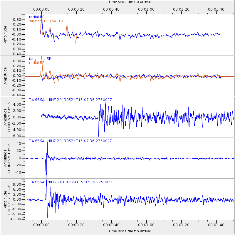
Signal To Noise
| Channel | StoN | STA | LTA |
| TA:656A: :BHZ:20130524T15:07:36.275002Z | 63.181293 | 1.7287834E-5 | 2.7362267E-7 |
| TA:656A: :BHN:20130524T15:07:36.275002Z | 19.636906 | 4.110798E-6 | 2.093404E-7 |
| TA:656A: :BHE:20130524T15:07:36.275002Z | 5.6772223 | 2.0095408E-6 | 3.5396553E-7 |
| Arrivals |
| Ps | 5.1 SECOND |
| PpPs | 16 SECOND |
| PsPs/PpSs | 21 SECOND |


