You are here: Home > Network List > TA - USArray Transportable Network (new EarthScope stations) Stations List
> Station 859A Kempfer Cattle CO., St. Cloud, FL, USA > Earthquake Result Viewer
859A Kempfer Cattle CO., St. Cloud, FL, USA - Earthquake Result Viewer
| Earthquake location: |
Sea Of Okhotsk |
| Earthquake latitude/longitude: |
52.2/151.4 |
| Earthquake time(UTC): |
2013/05/24 (144) 14:56:31 GMT |
| Earthquake Depth: |
624 km |
| Earthquake Magnitude: |
6.7 MW, 6.7 MB, 6.7 MW |
| Earthquake Catalog/Contributor: |
NEIC PDE/NEIC PDE-W |
|
| Network: |
TA USArray Transportable Network (new EarthScope stations) |
| Station: |
859A Kempfer Cattle CO., St. Cloud, FL, USA |
| Lat/Lon: |
28.06 N/80.90 W |
| Elevation: |
13 m |
|
| Distance: |
87.9 deg |
| Az: |
44.438 deg |
| Baz: |
330.843 deg |
| Ray Param: |
0.041680254 |
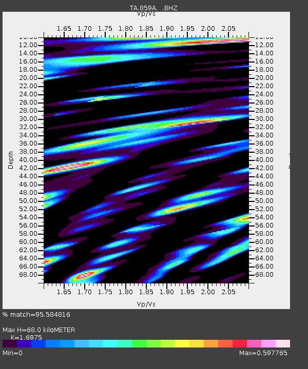
| Estimated Moho Depth: |
68.0 km |
| Estimated Crust Vp/Vs: |
1.70 |
| Assumed Crust Vp: |
6.134 km/s |
| Estimated Crust Vs: |
3.613 km/s |
| Estimated Crust Poisson's Ratio: |
0.23 |
|
| Radial Match: |
95.584816 % |
| Radial Bump: |
400 |
| Transverse Match: |
89.160225 % |
| Transverse Bump: |
400 |
| SOD ConfigId: |
512894 |
| Insert Time: |
2013-09-14 19:25:51.967 +0000 |
| GWidth: |
2.5 |
| Max Bumps: |
400 |
| Tol: |
0.001 |
|
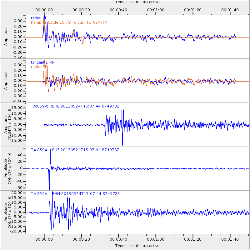
Signal To Noise
| Channel | StoN | STA | LTA |
| TA:859A: :BHZ:20130524T15:07:44.874978Z | 70.36772 | 1.909595E-5 | 2.7137372E-7 |
| TA:859A: :BHN:20130524T15:07:44.874978Z | 17.128826 | 6.9522116E-6 | 4.058779E-7 |
| TA:859A: :BHE:20130524T15:07:44.874978Z | 9.683739 | 3.4524032E-6 | 3.5651556E-7 |
| Arrivals |
| Ps | 7.9 SECOND |
| PpPs | 29 SECOND |
| PsPs/PpSs | 37 SECOND |


